A full circuit of a country you can cross in a day: up from Lake Tanganyika into the tea and the montane forest on the Congo–Nile watershed, east across the coffee hills to the northern lakes, down to the one park in Burundi you walk rather than drive, then Gitega and its drums, the falls and the escarpment in the south-east, the 1938 pyramid over a spring claimed as the southernmost source of the Nile, and back along the lake road.
Bujumbura
The city sits at about 774 metres on the northern tip of Lake Tanganyika — the second-deepest lake in the world, and the longest — with the hills starting immediately behind it. It stopped being the capital in 2019 and is now officially the economic one, which has changed less on the ground than the paperwork suggests. The central market burned down in January 2013 and was never rebuilt on its site; trade moved out to Kinama and Ruvumera, and walking one of those is a better hour than the empty plot. The Musée Vivant near the port is small and worth it. Sort cash today: this trip runs on paper money and the arithmetic is in the practical notes.
The Rusizi delta and the stone at Mugere
North first, and read the second half of this before you agree to it. Rusizi National Park is where the Rusizi river arrives at the lake through papyrus and a grove of Hyphaene palms — hippo in the channels, sitatunga in the reeds, and the river that produced Gustave, the outsized Nile crocodile a French naturalist tracked here for years and that a National Geographic team filmed in 2004; there has been no confirmed sighting since the mid-2010s and nobody will tell you whether he is dead. Now the part the brochures leave out: the delta is the one stop on this route inside the zone foreign advisories name. You reach it on the Gatumba road, the Rusizi here is the border with the DRC, and the same park's Rukoko sector further north lies in Bubanza province, which most foreign ministries tell you to avoid outright. Go to the delta sector only, in daylight, with a Bujumbura driver who has checked the road that morning, and drop it without arguing if the answer comes back wrong — it costs you half a day. Then south on the RN3 to Mugere, twelve kilometres out, where a rock is cut with the names Livingstone and Stanley and the date 25 November 1871: two weeks after the meeting at Ujiji, far down the eastern shore, the pair came up the lake together to settle whether the Rusizi flowed out of Lake Tanganyika or into it. It flows in, which is why the Nile is not here.
Up the escarpment to the tea
The RN1 climbs from the lake at 774 metres to around 2,000 at Bugarama in something like forty kilometres, and the temperature drops about ten degrees with it. Turn off for Teza, one of the five factories of the state tea board, where the plucked leaf comes in on the backs of day labourers from the hills around and the withering troughs run all afternoon. Tea is Burundi's second agricultural export after coffee and it is grown almost entirely on this ridge, on the boundary of the forest — which is the tension the next two days are about.
Kibira National Park
Four hundred square kilometres of montane forest along the crest of the Congo–Nile watershed, gazetted as a national park in 1980, and the same forest as Nyungwe on the Rwandan side of the border — one block with a line drawn through it. Take a ranger from the office and walk. There are chimpanzees in here and they are not habituated: you will more likely hear them a valley away than see them, and anyone selling you a guaranteed sighting is selling you something else. Go for the forest, the black-and-white colobus, the mountain birds and the fact that the water in the Rwegura reservoir below is collected by these trees — the dam was for decades the largest power station in the country, and the argument over where tea stops and forest starts is an argument about that catchment as much as about primates.
Across the coffee hills to Kirundo
East and north through Kayanza and Ngozi, which between them grow most of Burundi's washed arabica — the country's biggest agricultural export by value, produced almost entirely by smallholders with a few hundred trees each and processed at washing stations you pass every few kilometres. Stop at one in season and watch the sorting tables. Kirundo province at the top of the country is a different landscape again: a chain of shallow lakes on the Rwandan border. Lake Rwihinda is a managed reserve with no hippo and no crocodile in it, which is why you can go out on it in a dugout among the waterbirds at the end of the afternoon.
South to the Ruvubu
Down through Muyinga and off the tarmac to the northern gate of Ruvubu National Park. At about 508 km² it is the largest protected area in Burundi, gazetted in 1980 along roughly fifty kilometres of the Ruvubu river, and it is the emptiest place on this route — no villages inside the boundary, no lodge, and a campsite rather than a hotel. Arrange the ranger and the camping at the office when you arrive; nothing here is bookable from outside the country. Get in with enough light to put a tent up.
On foot along the river
Ruvubu is walked, not driven — there are tracks, but the point of the place is that a ranger takes you out into the valley on foot. Buffalo, hippo and crocodile in and along the river, several antelope, olive baboon and vervet in the gallery forest, and over four hundred bird species recorded. The lion and the elephant are gone and nobody pretends otherwise. Worth knowing what you are standing beside: the Ruvubu feeds the Kagera, the Kagera feeds Lake Victoria, and the White Nile leaves the far end of it — the water at your feet has 6,000-odd kilometres to run.
West to Gitega
Back out and across the central plateau through Karuzi — three and a half hours for not much distance, because the road surface decides the pace rather than the map does. Gitega was the seat of the monarchy, then a provincial town, and since a law passed in December 2018 and a parliamentary vote in January 2019 it has been the political capital: ministries moved into a town of something over a hundred thousand with almost no office stock, and you can see the results being built. The National Museum, founded in 1955, holds the royal regalia, the basketry and the photographic archive, and takes about an hour.
Gishora
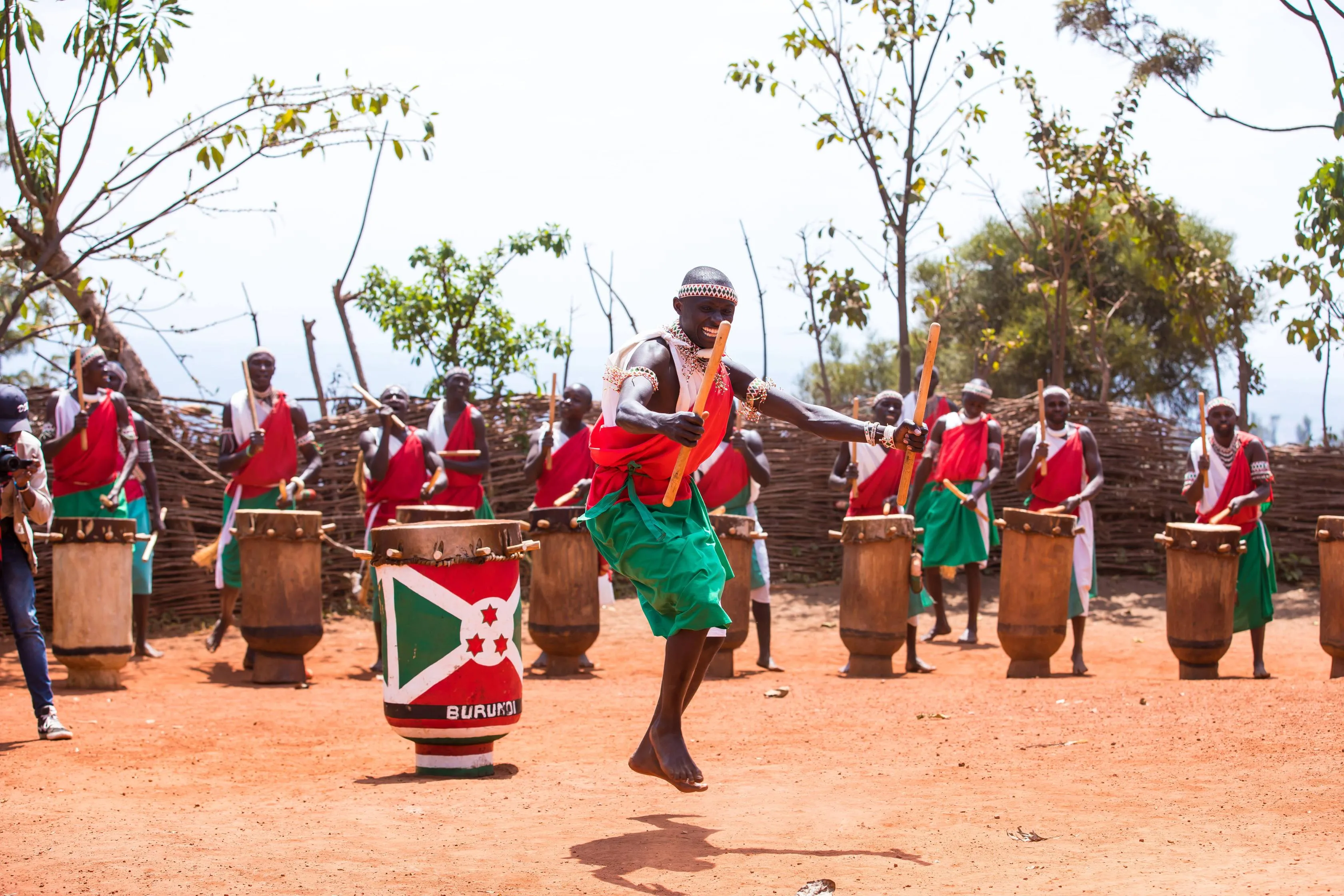
Seven kilometres north of town, on a hill, stands the drum sanctuary founded under Mwezi IV Gisabo in the second half of the nineteenth century. Two drums, Ruciteme and Murimirwa, are kept in the sacred hut and are never played. The ones that are played are carried in on the drummers' heads, set in a semicircle around the central inkiranya, and beaten by men from families who have done this for generations. Book the performance a day or two ahead through the site or your operator: since 2017 a drum performance outside an official state ceremony is a licensed activity requiring the culture ministry's authorisation, which is not a formality invented for tourists. Ask before you film.
The falls and the escarpment
South-east to Rutana, and two sites within an hour of each other. Karera is a set of four falls dropping over three levels through a protected block of about 142 hectares of gallery forest — a short walk between the viewpoints, and wet underfoot in every month. Then the Nyakazu escarpment, known locally as the German Fault after the colonial troops who fell back through it during the East African campaign of the First World War: a hard edge where the plateau ends and the Kumoso plain runs away east towards Tanzania. Both are guarded and both charge a small fee in francs.
The pyramid at Rutovu, then down to the lake
West along the ridge on laterite to Rutovu, in the old Bururi province, and up Mount Gikizi. At the top is a small stone pyramid built in 1938 by Burkhart Waldecker, a German geographer, over a spring he identified as the southernmost source of the Nile; a plaque gives the distance to the Mediterranean as 6,671 kilometres. The claim is contested — Rwanda makes its own for a spring in Nyungwe, and a 2006 expedition placed the most distant headstream there — so treat this as a marker of a nineteenth-and-twentieth-century argument rather than a settled fact. The water is real enough: it runs into the Ruvyironza, then the Ruvubu you walked beside four days ago. Then down through Bururi to Rumonge on the lake, losing about 1,200 metres.
Kigwena, and the lake road home
Twenty minutes south of Rumonge, Kigwena is a small reserve of lowland gallery forest almost on the shore — olive baboon in troops that hold up the road, monkeys overhead, and a canopy that has no business being at 800 metres, surrounded by the oil-palm belt that pays for this stretch of coast. Then north on the RN3, rebuilt over the last decade and the best road surface of the trip, with the lake on your left the whole way and the Congolese mountains across it. Under two hours to Bujumbura on tar, longer with stops. If your flight is the next morning, the beaches north of the city are twenty minutes out; people swim off the sandy bays, but not off the river mouths, where the crocodiles and the hippo are, and bilharzia is present in the lake, so a swim is a considered choice rather than a default.
Good to know
Arrange the visa before you fly. Most nationalities apply online through the government immigration portal, uploading the passport page, the yellow fever certificate and an itinerary; the one-month single-entry tourist visa runs around US$90, the three-day transit around US$40, and multiple entry costs more again — check the portal's own fee table, because it moves. Processing is quoted at about three working days, so allow a fortnight. A visa on arrival at Bujumbura exists for some passports at roughly the same US$90 in cash, and it is a fallback rather than a plan — people are refused boarding without a visa in hand. East African Community nationals enter freely. Passport valid six months, and carry a printout of the visa: police and army checkpoints are frequent, entirely routine, and go faster with paper. A yellow fever certificate is compulsory for all arrivals and is genuinely checked at the airport; it becomes valid ten days after the jab and, since 2016, lasts for life with no booster. Malaria is the serious medical issue and the whole country is risk, year-round, at every altitude on this route — Burundi declared a national malaria epidemic in 2019 with millions of cases — so take prophylaxis for the full twelve days and use a net at Ruvubu and on the lakeshore. Money is the single thing most likely to go wrong. The Burundian franc cannot be bought outside the country and cannot be spent once you leave, cards are accepted at perhaps two hotels in Bujumbura, and foreign cards do not reliably work in the ATMs. Bring the whole trip in cash US dollars, clean notes issued 2006 or later, mostly hundreds because small denominations get a visibly worse rate, and change at a bank or a licensed bureau rather than on the street. There is a wide and persistent gap between the official rate and the parallel one, which means the cost of this trip in euros is a moving number rather than a fixed one — price it the week you go. Do not photograph the airport, bridges, the presidential compound, government offices, police, soldiers or checkpoints. This is not nervous advice: phones are confiscated and people are detained over it, and the argument happens afterwards. Ask before photographing anyone, and ask again at Gishora, where filming the drummers may be a separate permission — a 2017 decree makes any drum performance outside an official state ceremony a licensed activity, with the culture ministry's authorisation and a fee, so a performance is booked and paid for rather than stumbled upon. French is the working language and Kirundi is what people actually speak; English gets you very little outside Bujumbura hotels. Drive June to August, the long dry season, or December to January for the short one. The long rains run roughly February to May, and in them the laterite from Muyinga into Ruvubu and the ridge road from Rutana to Rutovu stop being slow and start being a question. Little more than a thousand kilometres of Burundi's classified network is paved: the RN1 up the escarpment to Kayanza, the RN6 on through Ngozi towards Muyinga, the paved spur north to Kirundo, the RN2 into Gitega and the RN3 down the lake are tarred and fine, and everything else on this route is dirt that takes half again as long as the distance implies. Do not drive after dark anywhere. Foreign advisories consistently name the western border provinces of Cibitoke and Bubanza, the Rukoko along the Rusizi, and the frontier with the DRC as areas to avoid entirely, and several advise moving outside Bujumbura in two vehicles. This route stays out of Cibitoke and Bubanza with one exception you should decide about consciously rather than discover on the day: the Rusizi delta on day two sits on the DRC border at Gatumba, minutes from the crossing to Uvira, and the same park's Rukoko sector to the north is squarely inside the zone the advisories mean — go to the delta only, in daylight, and treat the Rukoko as closed. The delta in daylight is a routine outing for people who live in Bujumbura; it is still the only stop on this route your insurer may take a view on, and dropping it costs half a day and nothing else. Read your own government's advice the week you travel rather than the month you book. The parks are run by the state environment agency, fees are modest by East African standards — foreign adults pay around US$20 at Ruvubu — a ranger is compulsory at Kibira and Ruvubu, and everything is paid in cash francs at the gate because nothing is bookable online. Independent travel is possible and slow: minibuses connect every town on this loop cheaply, but they do not go up the Teza tea roads, to the Ruvubu gate or up Mount Gikizi, and a car with a driver who speaks Kirundi is the difference between doing this route in twelve days and not doing it. Hire through a Bujumbura operator and agree the fuel arrangement in writing before you leave.
Shorter or longer?
Add three or four days. Kibira and Rwanda's Nyungwe are one forest block split by a border, and Nyungwe — a national park with habituated chimpanzee groups, a canopy walkway and a UNESCO World Heritage inscription granted in 2023 — is what Kibira would look like with thirty years of investment. Cross at Kanyaru Haut north of Kayanza, and check the border's status before you commit: it has closed at short notice more than once. Budget for it separately, because this is the one part of the trip where a permit dominates the day: the chimpanzee permit for foreign non-residents runs around US$100 a head on top of park entry, the canopy walk is charged again, and both are booked through the Rwanda Development Board rather than paid at a gate.
Bujumbura and the Rusizi delta, up to Teza and Kibira, across to Gitega and Gishora, then Rutana for Karera and Nyakazu, Rutovu for the pyramid, and back up the lake road. Keeps the forest, the drums and the Nile source; drops the northern lakes and Ruvubu, which is also the only camping and the roughest driving.