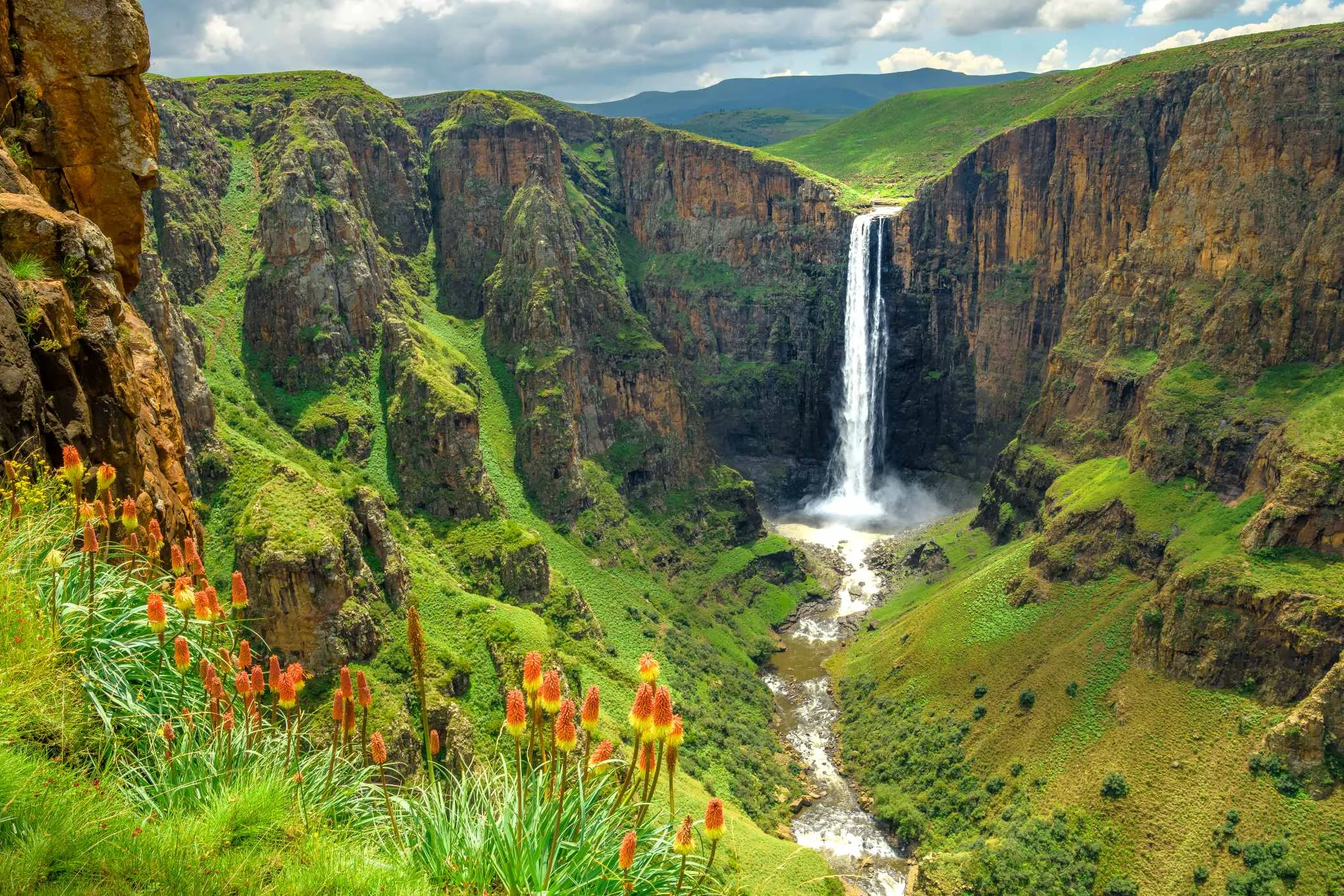
Twelve days across a country with no ground below 1,400 metres — Moshoeshoe's fortress hill and the mission presses at Morija, two days on a Basotho pony out of Malealea, the 192-metre drop at Maletsunyane, then the dams, tunnels and turbine hall of the project that sells this country's rain to the one neighbour it has, over Tlaeeng at 3,275 metres and out down the Sani Pass into KwaZulu-Natal.
Maseru
Arrive, and spend the day getting the practical things wrong in a town rather than on a pass. Change money — or rather do not, because the rand is legal tender here at par with the loti and the loti is not legal tender in South Africa, so keep rand for the way out. Buy a Vodacom or Econet SIM. Maseru sits on the Caledon river with South Africa on the far bank; the Maseru Bridge post is fifteen minutes from the centre, which is why almost nobody arrives any other way. The Basotho Hat craft centre and the Sunday markets are the whole of the sightseeing, and that is fine — the country is not in its capital.
Thaba-Bosiu and the Kome caves
Twenty-five kilometres east, a flat-topped sandstone hill with a single practicable approach up the Khubelu pass. Moshoeshoe I moved his people onto it in July 1824 and the hill was never taken by assault: Ndebele raiders in 1831, a British column that fought at Berea in 1852 and the Free State Boers who besieged it in 1865 all failed on the same ground. What the hill could not hold was the farmland. The wars of 1858 and 1865–68 cost Moshoeshoe most of the arable land west of the Caledon, and in 1868 he asked Britain for protection rather than lose the rest — which is why Basutoland was a High Commission Territory in 1910 and stayed out of the new Union of South Africa, and why the border you crossed to get here exists at all. Guides from the visitor centre take you up; the royal graves are on the summit. Carry on north-east afterwards to Ha Kome, where mud-and-stone dwellings built under an overhang in the nineteenth century are still lived in by descendants of the families who cut them.
Morija
Forty-five kilometres south on the A2. The Paris Evangelical Missionary Society settled here in 1833 at Moshoeshoe's invitation — he wanted literate advisers and a counterweight to the Cape — and the mission put in the first printing press in the country. Morija Museum and Archives holds the printed record of the nineteenth century here: the mission registers, the first Sesotho newspaper, and the fossil and stone-tool collections. Dinosaur trackways are exposed in the sandstone a short walk out of the village; the guide from the museum is worth taking, because they are easy to walk over without seeing.
Over the Gates of Paradise to Malealea
South to Motsekuoa, then west on a gravel road that climbs to a nick in the ridge with a stone marker put there by the trader Mervyn Smith in the 1930s, telling the wayfarer to pause and look upon a gateway of paradise. Below it is the Malealea valley and Smith's old trading store, which has taken guests since 1986. The lodge is the visible half of an arrangement with the surrounding villages: the pony owners, guides and the choir are from them, and a share of what you pay goes to a community development fund rather than to the bar. Walk to the Botso'ela falls in the afternoon to get the legs used to the altitude.
A day on a pony
The Basotho pony is a working animal descended from Cape horses left here in the 1820s, bred small and short-legged for ground that defeats vehicles, and in most of these valleys it is still how people get to a clinic. A full day out of Malealea goes over the ridge into the Makhaleng gorge, past San rock paintings under an overhang and through villages with no road to them. You do not need to ride; the ponies are led at a walk and the guides are from the villages you pass through. Take a hat, take more water than you think, and expect to be sore.
North-east to Semonkong
There is a direct track from Malealea to Semonkong over the Ketane escarpment and it is a long, slow, genuinely rough day that needs low range and local advice on the river crossings. The sane version goes back out to the A2, north through Morija to the Roma junction, then south-east on the tarred A5 up the Makhaleng valley — about 170 kilometres and four hours, most of it climbing. Semonkong means the place of smoke, after the spray that stands over the falls in the gorge below the village, and it is a horse town: on Saturdays the trading post is a car park for ponies.
Maletsunyane
The Maletsunyane river goes over a basalt lip and falls 192 metres in one drop into a gorge it has cut several hundred metres deep. Walk the rim path to the viewpoint in the first two hours of light, when the spray has not yet blown out, or take a pony down to the plunge pool and back — about five hours, and the return climb is the work. The lodge also runs a 204-metre abseil from the cliff beside the falls, listed by Guinness as the longest commercially operated single-drop abseil anywhere. It takes most of a day, it is not cheap, and you are on the rope for a good part of an hour.
Over Bushman's Pass to Mohale
Back down the A5 to the Roma junction and east onto the A3, which climbs Bushman's Pass and then Blue Mountain Pass at 2,634 metres inside twenty kilometres. Mohale Dam is at the bottom of the far side: 145 metres of concrete-faced rockfill across the Senqunyane, finished in 2002 as the second phase of the water project, and connected to Katse by a 32-kilometre tunnel through the mountain between them. There is a visitor centre and a guided walk onto the crest. The reservoir drowned villages and the graves in them; the resettlement sites are visible on the slopes above the water and the guides will tell you about the compensation if you ask.
Mokhoabong Pass to Thaba-Tseka
Eighty-five kilometres of tarred mountain road east over the Mokhoabong Pass, which tops out near 2,880 metres and spends most of its length on a ridge with the ground falling away on both sides. Thaba-Tseka was built in the 1970s as the administrative centre for a district that had never had one, and it is the place to understand what the highlands road programme actually changed: before the water project there was no tarred road east of the Maloti at all. Fuel here. It is the last reliable pump before Katse.
North to Katse
Ninety kilometres north along the arm of the reservoir, part tar and part gravel, about three hours. Katse Dam is 185 metres of double-curvature concrete arch across the Malibamatšo, the highest dam in Africa when it was completed in 1996, and it is the head of the whole system: a 45-kilometre tunnel takes the water north under the mountains to the turbines at 'Muela and on into South Africa. The visitor centre runs tours into the dam wall itself at set times — book at the gate in the morning for the afternoon. The botanical garden above the village exists because the reservoir drowned valley habitat of plants that grow only in these mountains — the spiral aloe among them — and it holds what was lifted out before the water came up.
Mafika-Lisiu, 'Muela and the Moteng Pass
The A8 west out of Katse climbs to Mafika-Lisiu at 3,090 metres, where Bokong Nature Reserve has a visitor centre on the escarpment edge and a walk out to the Lepaqoa waterfall, which freezes into a column in winter. Down to Pitseng and Hlotse, north to Butha-Buthe, then east and up again: 'Muela is where the tunnel from Katse comes out, drops through three turbines for 72 megawatts and continues to the border, and it is the only power station of any size in the country — enough for a large share of demand, with the remainder still bought from South Africa and Mozambique. Beyond it the road takes the Moteng Pass in a set of hairpins that lorries regularly fail to hold, and ends at Oxbow under the ski slope at Mahlasela.
Tlaeeng, Mokhotlong and down the Sani
The A1 crosses Tlaeeng Pass at 3,275 metres — the highest tarred road on the continent, with nothing above it but the Maloti ridgeline — and drops to Mokhotlong, a district town on the upper Senqu that the Polihali dam works have visibly enlarged. Turn south on the A14, tarred all the way to the lip of the Sani Pass at 2,876 metres, where there is a border post, a lodge and a bar that has been advertising itself as the highest in Africa for decades. Thabana Ntlenyana, 3,482 metres and the highest point in southern Africa, is a long day's walk east of here if you want it. Otherwise clear immigration and start down: the South African side of the pass is unsurfaced, 4×4 only, and loses 1,300 metres in about eight kilometres of hairpins.
Good to know
Almost everyone arrives overland from South Africa, so plan the South African side first: you will exit and re-enter it, and a single-entry South African visa ends the trip at Maseru Bridge. Most EU, UK, US, Canadian, Australian and SADC passports need no Lesotho visa, but the stay granted is stamped at the post and is frequently shorter than people assume — read the number before you drive away. Everyone else applies in advance at the eVisa portal, evisa.gov.ls; there is no visa on arrival for nationalities that require one. Border posts keep different hours: Maseru Bridge and Ficksburg Bridge at Maputsoe run 24 hours, Caledonspoort roughly 06:00–22:00, but Sani Pass is roughly 08:00–16:00 on the Lesotho side and 06:00–18:00 below, it closes in snow, and arriving at the top at half past four means sleeping there. Yellow fever certificates are asked for only from arrivals who have been in a country with risk of transmission. There is no malaria anywhere in Lesotho — the altitude sees to it — which removes the single biggest medical decision most southern African trips involve. Altitude is the one that replaces it: the lowest ground in the country is 1,400 metres, the highest of any country's low point in the world, and the highland nights of this route are spent between 2,000 and 2,600 metres — over 3,000 if you take the Afriski option at Mahlasela — so give the first two days to Maseru and Morija before going high and take the first night on the passes gently. The currency is the loti, pegged one-to-one to the rand, and rand circulate freely here — but maloti are not accepted in South Africa, so spend or change them before you leave. Cards work in Maseru and at the bigger lodges and nowhere else; carry cash for fuel, guides and ponies. Self-drive is realistic and it is how this route is meant to be done, but the vehicle needs high clearance and four-wheel drive, and the paperwork matters more than the car: a South African rental company requires a signed cross-border letter arranged one to two weeks ahead with a fee attached, many contracts exclude Lesotho outright, and a large number of them name the Sani Pass specifically as prohibited — check that clause before you plan the exit, or reverse the route and come back out through Maseru. At the border you pay a small road levy and show the letter and the vehicle registration. Fuel is available in Maseru, Morija, Roma, Semonkong, Thaba-Tseka, Hlotse, Butha-Buthe and Mokhotlong and effectively nowhere between them; fill at every one of those on the highlands section. Do not drive at night anywhere in this country. Livestock is herded on the tarred passes after dark, the animals are unlit, and the herd boys walking with them are unlit too. No part of this route crosses a conflict zone or a no-go region — there is nothing here comparable to the Sahel borders or the Horn — but Lesotho does have one of the world's higher rates of violent crime, and the practical shape of it is muggings and vehicle theft in Maseru rather than anything in the mountains: do not walk central Maseru after dark, and park inside a compound. The politics have twice put the army on the streets in the last decade, most seriously in 2014; it is worth reading current advisories before you fly, and it has never affected the highlands villages this route spends its time in. Seasons split hard: November to March is the rain, which arrives as violent afternoon thunderstorms with lightning that kills people on ridges most years, and it turns the gravel sections and every unbridged crossing into a judgement call. June to August is dry, blue and very cold — nights well below freezing on the passes, and Moteng, Mahlasela and Tlaeeng close for snow at a few hours' notice, so check with your lodge before committing to a crossing. April, May, September and October are the reliable months. Sesotho and English are both official and English is widely spoken. Ask before photographing people, and do not photograph the dam infrastructure outside the official tours.
Shorter or longer?
Three or four more days: from Sani Top or Mokhotlong work south through Qacha's Nek to Sehlabathebe, Lesotho's first national park and part of the Maloti-Drakensberg World Heritage Site, for sandstone arches, rock art and the highest and emptiest walking in the country. The roads in are slow and the accommodation is a lodge and a few huts.
Maseru, Thaba-Bosiu, then straight up the A1 to Butha-Buthe, Ts'ehlanyane, 'Muela, Oxbow and Mokhotlong, out at Sani or back the way you came. Keeps the passes, the water project and the high country; drops the ponies, Maletsunyane and the entire south-west — which is also most of the driving.