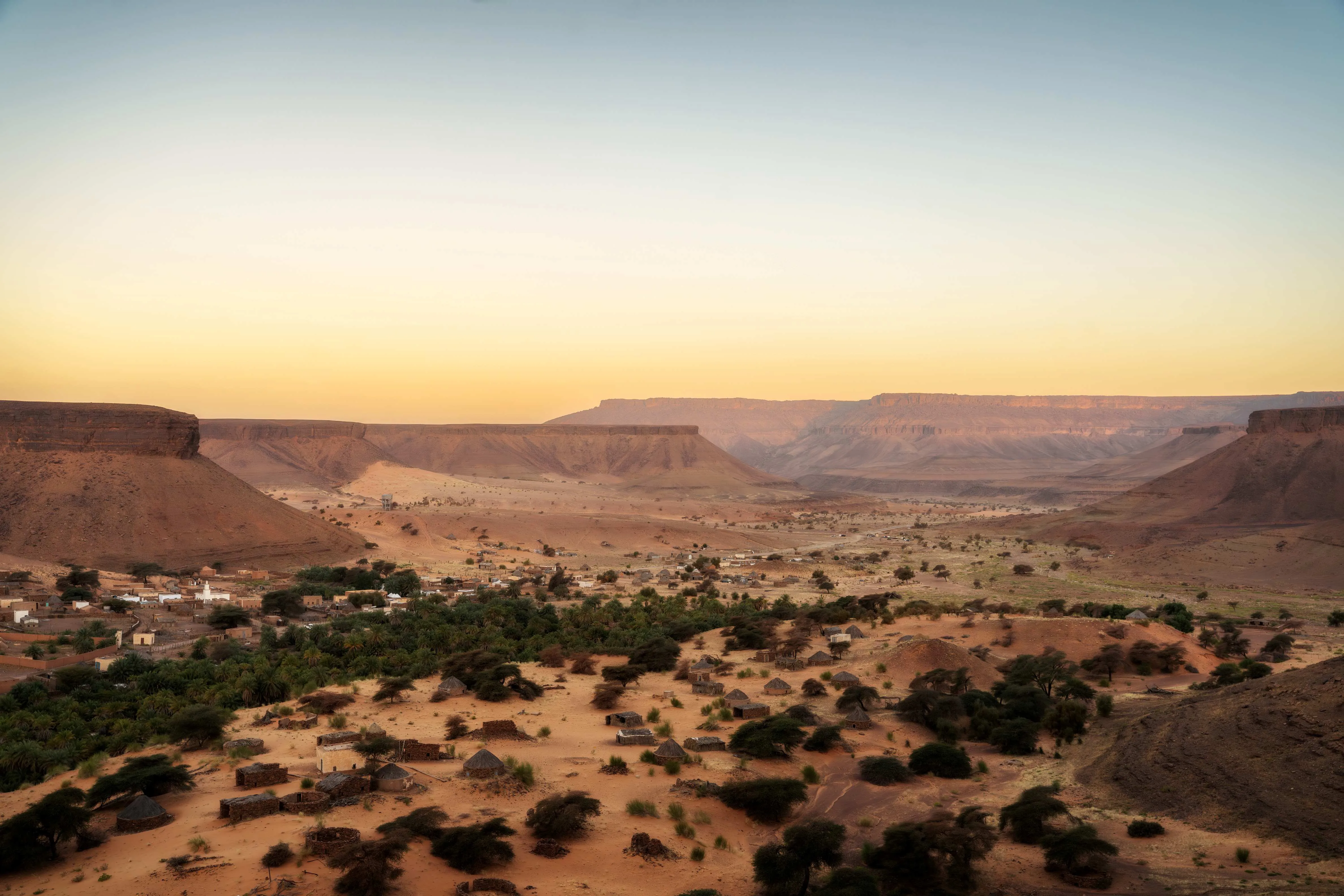
North from Nouakchott onto the Adrar plateau — a palm oasis in a gorge, two medieval caravan towns with family manuscript libraries still in them, and a forty-kilometre geological bullseye you can only really read from the rim — then out to a railway halt in the middle of nowhere to ride an iron ore train four hundred and eighty kilometres to the Atlantic, and back down the coast to the sandbanks of the Banc d'Arguin.
Nouakchott
A capital that did not exist as a city when it was chosen to be one. In 1957 this was a village of a few hundred people beside a colonial fort; the site was picked because it was roughly halfway between the Moorish north and the Black African south and belonged to neither, and building began before independence in 1960. It now holds something approaching a third of the country. Give the afternoon to the Port de Pêche, where several hundred painted wooden pirogues are hauled up the beach on ropes by teams of men and the catch is gutted and sold on the sand within an hour of landing. Do not photograph the police, the port cranes or anything with a soldier near it.
North to Atar
Four hundred and fifty kilometres of tarmac, and the only long paved day of the trip. The road runs inland through Akjoujt, a copper and gold town where the mine has opened, closed and reopened under three different owners since the 1970s, then climbs onto the Adrar. Sand drifts across the carriageway in ribbons and is the actual hazard here — hit one at ninety and the car goes where the sand says. Atar is the plateau's market town and the place your desert vehicle, fuel and guide are arranged; it also has the airstrip that seasonal charters from France use in winter.
Terjit, the Amogjar pass, and on to Chinguetti
South first: Terjit is a spring in a cleft in the escarpment, forty-five kilometres from Atar, where warm and cold water come out of the rock a few metres apart under a roof of date palms. It is small, it is busy at midday, and it is worth being there at eight. Back through Atar and east over the Amogjar pass — the switchbacks were cut by the French and the shell of a fort near the top is not a fort but a set built for the 1984 film Fort Saganne and never taken down. Below the pass at Agrour are neolithic rock paintings of cattle and human figures, on overhangs a local guide has to show you because nothing is signed. Into Chinguetti in the late afternoon.
Chinguetti
The old ksar is across a dry wadi from the newer town and the dunes are winning: sand stands against walls at first-floor height and houses at the western edge have been abandoned to it. The Friday mosque has a square stone minaret and has been in use for centuries; it is not open to non-Muslims and the courtyard is photographed from outside. What you are really here for is the libraries — five or six family collections of manuscripts, kept by the households that inherited them, on Maliki jurisprudence, arithmetic, astronomy, medicine and Arabic grammar, some of them written here and some carried back from Cairo and Fez by men who had gone on pilgrimage. The Habott collection is the largest. You are shown them by the owner, a small fee is expected, and the honest question the visit raises is who is supposed to pay to conserve a national archive that is legally private property. Chinguetti and Ouadane, with Tichitt and Oualata, were inscribed by UNESCO together in 1996.
North-east to Ouadane
A hundred and twenty kilometres of piste across the plateau — graded in stretches, soft sand in others, and three to four hours whichever way it goes. This is the section where a guide stops being a courtesy: there are multiple sets of tracks, they diverge, and the wrong one costs you the day. Ouadane sits on a shelf above a palm valley. The old town below the modern village is a stepped ruin of dry stone streets founded in 1147 by Berber traders, abandoned in stages after the caravan trade moved, and partly stabilised in the last twenty years. Walk it in the last hour of light with someone from the village.
The Guelb er Richat
Thirty kilometres north-east of Ouadane in a straight line and nearer fifty by the sand, a set of concentric rock ridges about forty kilometres across, and for decades it was assumed to be a meteorite crater. It is not: there is no shocked quartz and no impact melt, and the current reading is a deeply eroded dome pushed up by an igneous intrusion, with the harder quartzite beds standing proud as rings. From the ground you see one ridge, then scrub, then another ridge, and the shape only assembles if you climb onto the inner rim and think about what you are standing on. Camp inside it or run out and back in a long day. The drive is unmarked open desert and is not a self-drive proposition.
Down to the railway at Choum
The long transfer, and the one to start at six. Back south-west to Atar on the improved road and piste, refuel and eat properly there, then a hundred and twenty kilometres almost due north on piste to Choum. Choum is a railway halt with a few concrete buildings, a scatter of tyres and a lot of people waiting. The southbound train comes down loaded from the mines at Zouérate and there is no timetable you can hold anyone to — late afternoon is the usual guess and well after dark is common. Buy the ticket for the single passenger carriage if you want a bench, a roof and a door; the ore is free and is what almost everyone rides. Load water, food, a blanket, goggles and a head-covering before you leave Atar, because Choum sells almost nothing.
The ore train to Nouadhibou
Four hundred and eighty kilometres of line to the coast and roughly twelve hours of it, most of them in the dark. The train is over two kilometres of wagons behind three or four diesel locomotives and it moves at the speed of a slow bicycle for long stretches. On top of the ore you get the sky, the cold — genuinely cold, the Sahara loses its heat fast and you are doing forty kilometres an hour into the wind — and a fine red dust that gets into the camera, the phone, the food and the lungs. Nothing on the train is designed for you. It stops at Nouadhibou's Cansado yards a little after dawn and you climb down black. The line was built to carry iron ore and it still does; you are cargo it tolerates.
Nouadhibou and Cap Blanc
Sleep, wash twice, then look at the town that the railway exists to reach. The ore terminal loads ships in the sheltered deep water of the Baie du Lévrier, and beside it is one of the largest fishing ports in West Africa, working the cold Canary current that makes these waters productive and makes the EU access agreement a recurring item in Mauritanian politics. The ship graveyard the town was famous for is mostly gone — dozens of hulks were cut up and removed from the early 2000s under a salvage contract, and only a few rusted shapes are left in the bay. Drive down the peninsula towards the Cap Blanc lighthouse. The peninsula is divided lengthwise: the eastern side is Mauritania, the western side is Western Sahara, and the Mediterranean monk seal colony everybody has read about is on the far shore and not somewhere you can go. Do not photograph the port, the SNIM installations or the checkpoints, and do not drive off the tracks near the border — there is uncleared ordnance out there.
South to the Banc d'Arguin
Back down the paved coast road roughly two hundred and fifty kilometres to Chami, a town that did not exist fifteen years ago and grew out of an artisanal gold rush — thousands of men with metal detectors, and a state-run processing plant built to keep the mercury off the open ground. From Chami a piste of about ninety kilometres runs west to Iwik, an Imraguen village inside the national park. The last stretch crosses sabkha, salt flat that is firm in the dry season and a trap after rain. Arrange the boat for the morning when you arrive.
Under sail on the banks
Banc d'Arguin was gazetted in 1976 and inscribed by UNESCO in 1989: twelve thousand square kilometres of shallow water, seagrass and sandbank where the Sahara runs into the Atlantic. Something over two million waders winter here, the largest concentration known anywhere, and in the northern spring the flats are covered with birds that will be in Siberia within weeks. The Imraguen are the only people permitted to fish inside it, from lateen-rigged wooden lanches with no engines, which is why the water is quiet enough to hear the birds from the boat. Their old technique of beating the water to bring bottlenose dolphins in to drive mullet towards the nets is now mostly a story rather than a practice, and worth asking about rather than expecting. Sail on the morning tide, walk a sandbank at low water with a park guide, and go: it is ninety kilometres of piste back to the road and another two hundred and fifty of tarmac south to Nouakchott, so the boat has to be off the water by early afternoon.
Good to know
Go between November and March. April is already hot, and from May to September the interior sits above 45°C and the Adrar circuit effectively closes; the far south gets a short rainy season around July to September that this route does not touch. Most nationalities get a visa on arrival at Nouakchott–Oumtounsy and Nouadhibou airports and at the main land crossings — the fee has sat at €55 for several years, it is biometric, and it is paid in euro cash at the desk, so bring the exact note. Confirm the current arrangement before you fly, because it has been announced as changing more than once. The ouguiya is a closed currency: you cannot buy it before you arrive or spend it after you leave, and euros are the cash that works everywhere. It was redenominated on 1 January 2018, one new ouguiya for ten old ones, and a great many people still quote prices in the old money, so confirm which you are being told. It is also one of only two circulating currencies in the world that is not decimal — five khoums to the ouguiya. ATMs are reliable in Nouakchott and Nouadhibou and nowhere else on this route; cards are not accepted in Atar, Chinguetti, Ouadane or Iwik. Draw everything you need before you leave the capital. Alcohol is illegal throughout the country and there is no discreet exception for hotels. A yellow fever certificate is asked for from arrivals who have come from a country with risk of transmission; the risk zone inside Mauritania is the southern strip along the Senegal river, which this route stays well clear of, so if you are flying in from Europe you will probably not be asked and should carry the certificate anyway if you are connecting through West Africa. Malaria is a southern and seasonal problem here rather than a national one — the Sahara has none — and a travel clinic will usually not prescribe prophylaxis for a purely northern and coastal itinerary in the dry season, but ask rather than assume, and take the bite precautions regardless. Checkpoints are constant and the drill is the fiche: a photocopied slip with your passport number, visa number, nationality, occupation and vehicle details, handed over at each post. Print thirty of them before you leave home. Doing this turns a twenty-minute stop into a two-minute one, and every driver in the country will tell you the same thing. Independent travel is legally possible and practically unwise. There is no marked route across the Adrar, the piste from Chinguetti to Ouadane splits and rejoins repeatedly, the run out to the Richat is open desert with no track at all, and recovery from a mistake is your own problem — a hired 4×4 with a driver who knows the plateau is the normal arrangement and costs little more than the car on its own. The Adrar circuit and the coast are calm and have been for years; Mauritania has not suffered a jihadist attack on its own soil since 2011, which is not true of any of its Sahelian neighbours, and the small tourist trade that the 2007 murders near Aleg destroyed has come back on the strength of it. The advisories that remain are real and geographic: the Malian border zone in the east and south-east, the desert north-east of the Adrar, and the strip along the Western Sahara berm, where there is uncleared ordnance. Do not improvise routes towards any of them. Photography is the other way to get into trouble — the port at Nouadhibou, the SNIM railway installations, military posts, police and government buildings are all off limits, and people have had cameras taken. Ask before photographing anyone, and expect to be asked for something in the Adrar. Finally, the train: it has no timetable and the northbound and southbound workings both slip by hours. Build a spare day between the train and any onward flight, and do not book the Nouakchott departure for the same evening you expect to reach Nouadhibou.
Shorter or longer?
Add two or three days. Fly or drive up to Zouérate, look at the Kédia d'Idjil workings that the entire railway was built for, and board there rather than at Choum — roughly 700 kilometres and sixteen hours instead of twelve. Zouérate is a company town and access to the mine itself needs SNIM's permission arranged well in advance; the desert north-east of it is under advisory and is not a place to wander.
Nouakchott, Atar, Terjit and the Amogjar pass, Chinguetti, Ouadane and the Richat, then back down the tarmac to the capital, with the Banc d'Arguin as a two-night detour off the coast road. Keeps the caravan towns and the birds and drops the twelve hours in the ore, which is the part of this trip people either want above everything else or do not want at all.