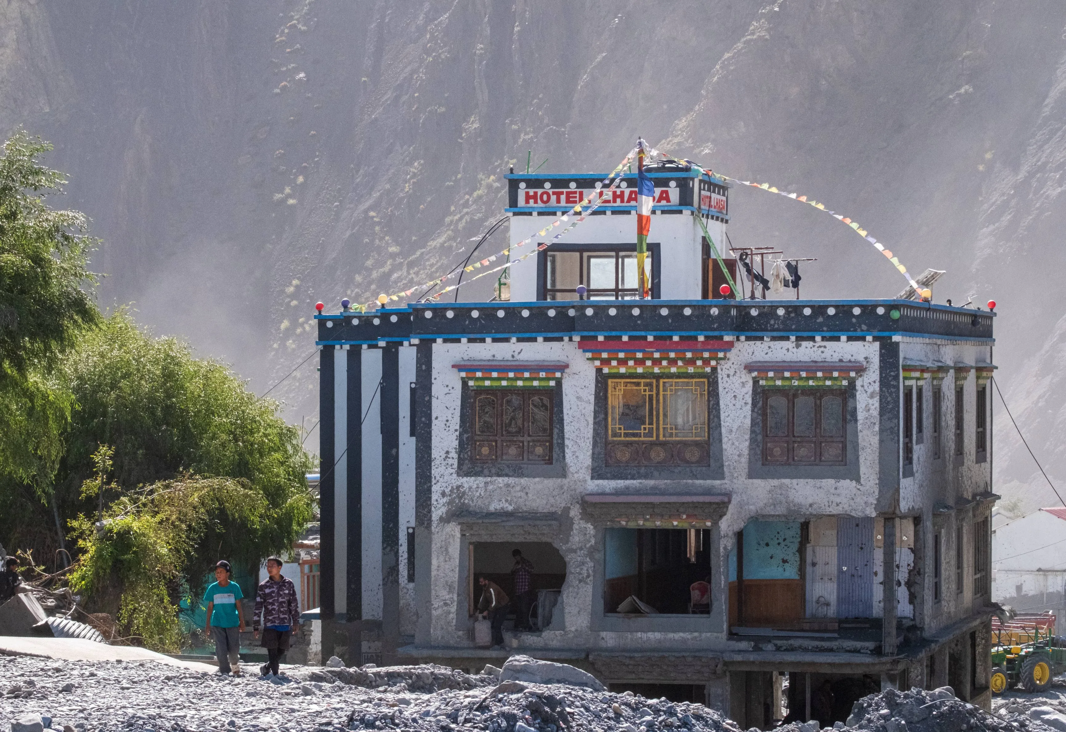
Arzu / stock.adobe.com
The Gateway That Flooded Twice
Rasuwagadhi is the only major road crossing between Nepal and China, and the single overland funnel for Kailash pilgrims, Langtang trekkers, and most of Nepal’s China trade. On August 26, 2026, it was destroyed for the second time in thirteen months. The first official explanation — an earthquake — turns out never to have happened.
This text is a verified snapshot as of 8:15 a.m. Nepal time on August 27, 2026. The registers behind it are less than thirty hours old and are moving in both directions. Material changes to the figures will be published through Corrections, not through silent edits. Every number in the text carries its institution and cutoff time.
Practical information for travelers — road status, the border crossing, Langtang, and Kailash bookings — is in the service appendix at the end of the text.
At 8:37 a.m. Nepal time on Wednesday, August 26, 2026, seismographs across the Himalaya registered a sharp signal near the border between Nepal and China. Within hours, the United States Geological Survey had catalogued it as a magnitude 4.4 earthquake. Within hours of that, Nepal’s foreign minister stood up in the House of Representatives and told the country that this earthquake had shaken loose an avalanche, and that the avalanche had caused the flood then tearing down the Bhotekoshi valley.
By Thursday, the USGS had withdrawn the earthquake. The agency said the event, at magnitude 5.2, was a glacial collapse and debris flow rather than an earthquake, and that further analysis of nearby seismic stations, long-period seismic waves, and satellite imagery had established that no earthquake had occurred.
The mountain did not shake and then fall. The mountain falling was the signal.
The State of the Data
The Nepali toll used in this text has a cutoff of 8:15 a.m. Nepal time (NPT, UTC+5:45) on August 27, 2026, and comes from a Nepal Police bulletin. The register of people unaccounted for shares that cutoff and that source. The Chinese figures were released by Xinhua on Thursday, August 27, and relayed by international agencies; they are official state figures, not the product of independent verification. The technical assessment of the cause comes from the USGS and from the International Centre for Integrated Mountain Development (ICIMOD) and remains preliminary. All figures are provisional.
Register | Institution and cutoff | Figure |
|---|---|---|
Deaths, Nepal | Nepal Police bulletin, Aug 27, 8:15 a.m. NPT | 165 bodies recovered across eight districts |
Unaccounted for, Nepal | Nepal Police bulletin, Aug 27, 8:15 a.m. NPT | 826 total — 579 tourists, 44 Nepali Army, 28 Nepal Police, 13 Armed Police Force, 161 Rasuwa residents, 1 Nuwakot resident |
Tourists, nationality breakdown | Nepal Tourism Board via AP, Aug 27 | More than 400 foreign nationals; 47 U.S., 34 Australian, 33 British, 24 Canadian |
Deaths and missing, Tibet | Xinhua and CCTV, Aug 27 | 3 dead, 558 missing at Gyirong Port, 260 of them foreign nationals |
Cause | USGS, Aug 27 | Magnitude 5.2 glacial collapse and debris flow; no earthquake occurred |
The Nepali and Chinese registers of the missing cannot be added together. Whether the two states are counting some of the same people has not been established.
How to Read Numbers After a Disaster
Five rules that govern this text — and every future disaster ExplWorld covers.
- No number without an institution, a date, and a cutoff time. The most recent number on social media is not necessarily the most accurate.
- Different registers are not automatically a contradiction. An operational count, a forensic register, and regional reports have different methodologies, channels, and cutoffs.
- A number that goes down does not necessarily mean a cover-up. Corrections after removing duplicates and locating the missing tend to be a sign of a working system, not of manipulation.
- A model is not a survey. Estimates of exposure, landslides, or economic losses are generated automatically from models; field verification comes later and may differ.
- Official is not the same as independently verified. Government figures relayed by news agencies should be published with attribution, not as definitive fact.
1. Eight Thirty-Seven: The Earthquake That Was Not an Earthquake
Automatic seismic detection is built to answer one question quickly: did the ground rupture, where, and how hard. It is very good at that. It is less good at telling a rupture apart from several million tons of ice and rock leaving a mountainside at once, because both send long-period energy through the same crust to the same instruments.
The USGS first reported a magnitude 4.4 earthquake early Wednesday, roughly 66 kilometers north of Kathmandu, near the border. By Thursday it had revised that to a magnitude 5.2 glacial collapse, citing nearby stations, long-period waves, and satellite imagery.
In the twenty-four hours between those two statements, the first version had already become an official explanation. Foreign Minister Shishir Khanal told parliament that preliminary information indicated an earthquake at around 8:37 a.m. may have triggered an avalanche, which in turn caused the flood — while stressing that the information still needed verification. The caveat was real. It did not travel as far as the claim.
Nepal’s own scientific agencies never endorsed the earthquake. The National Disaster Risk Reduction and Management Authority said preliminary study of Planet Labs satellite imagery showed a snow-and-rock landslide on the Nepal–China border, roughly 20 kilometers northeast of the Rasuwagadhi crossing, which sent a debris-laden flood down the Lhende Khola. The Department of Hydrology and Meteorology’s Flood Forecasting Division chief, Binod Parajuli, said imagery received from Chinese authorities showed debris blocking the river about 20 kilometers above the Miteri Bridge, forming a temporary lake that then burst. Rijan Bhakta Kayastha, a climate researcher at Kathmandu University, told Kantipur that an ice avalanche appears to have fallen into and dammed the Lhende, and ruled out heavy rainfall as the main cause.
ICIMOD, which coordinates cryosphere science across the region, was careful. Its head of climate and environmental risks, Qianggong Zhang, said an ice avalanche in the Lhende Khola was the suspected trigger but that the cause remained unconfirmed.
There is a difference between three institutions converging on ice and rock, and one minister naming a cause in parliament thirty minutes after being handed a preliminary note. Both were reported the same way. Only one of them was later withdrawn by the agency that issued the underlying data.
The reader’s takeaway is not that the government lied. It is that in the first hours of a disaster, the fastest available explanation is an automated classification, and an automated classification is a hypothesis. A government that repeats it has not verified it. It has relayed it.
2. A Dry Morning and No Warning
There was no storm to watch. Sanjeev Adhikari, a meteorologist with the Flood Forecasting Division, said the flooding did not appear to have been caused by rainfall in Rasuwa itself, and that satellite imagery showed significant rainfall on the Tibetan side of the border. People in the valley were doing ordinary Wednesday-morning things.
Rasuwa’s chief district officer, Narendra Pariyar, said he received word of a sudden major flood at around 9:15 a.m., and that it had come from the Tibet side. The NDRRMA’s situation report places the impact at approximately 8:40 a.m. Xinhua reported that the mudslide struck at approximately 10:30 a.m. Beijing time — 2:30 a.m. GMT — and that it originated on the Nepalese side. Converted to Nepal time, the Chinese figure is 8:15 a.m., twenty-two minutes before the seismic signal that the collapse itself produced. The two official times have not been reconciled, and this text does not attempt to reconcile them.
Chameli Gurung, deputy chair of Uttargaya Rural Municipality, said around a dozen settlements were affected, including Syaphrubesi, Betrawati, Mailung, Salletar, Shantibazar, Pairebesi, Khalti Basti, Sole, Trishuli, and Battar. ICIMOD said hydrological observations showed the exceptional speed and scale of the wave, with water levels at one point on the Trishuli rising by as much as nine meters — about 27 feet — over half an hour.
A nine-meter rise in thirty minutes on a river that had given no prior sign is not a flood in the sense most readers picture. It is a wall arriving. Early-warning systems built around rainfall thresholds and rising gauges cannot see it coming, because there is nothing to rise until it is already there.
3. The Valley Everyone Goes Up
Rasuwagadhi is not one road among several. It is close to the only one.
The crossing accounts for nearly 70 percent of Nepal’s trade with China. It is also the overland gateway for the Kailash Mansarovar Yatra: pilgrims drive north from Kathmandu through Dhunche and Syabrubesi, cross at Rasuwagadhi, and acclimatize at Kerung before the long westward drive. And Syabrubesi is the trailhead where every Langtang trek begins.
Trade, pilgrimage, and trekking all use the same forty kilometers of riverside road. Bashu Kumar Adhikari, managing director of Touch Kailash Travels & Tours, said 390 pilgrims, including 93 Nepalis, were scheduled to cross the border on Wednesday, and that as of 3 p.m. contact had been established with only a few of them.
That single-funnel geography explains a register of missing that would otherwise look impossible for a district of Rasuwa’s size. It is also why the damage is not recoverable by clearing a road. Major sections of the Pasang Lhamu Highway were swept into the river, cutting the northern border area off from Kathmandu, and helicopter crews reported so much debris across the valley floor that in places there was effectively nowhere safe to land. The helipad at Timure was among the things the water took.
A corridor that concentrates every kind of traffic into one valley is efficient until the day it is not. Concentration is not itself a failure of planning; the Himalaya does not offer many alternatives. But it does mean the consequences of a single event are not distributed. They arrive all at once, to everyone.
4. Thirteen Months Earlier, the Same River
On July 8, 2025, at around three in the morning, water came down this same valley. Nepal’s Department of Hydrology and Meteorology concluded that a supraglacial lake outburst in China had caused it, placing the lake about 36 kilometers north of the border at Rasuwagadhi at an altitude of around 5,150 meters, and noting that its area had fallen from roughly 0.74 to 0.60 square kilometers. ICIMOD later traced that lake to a pond that had formed at the end of December 2024 and grown through the following June.
That flood took the Miteri Bridge — the Friendship Bridge, the physical link between the two countries — along with the customs yard, dozens of vehicles, and much of the Timure dry port. The crossing stayed completely shut from July 8 until a 91-meter Bailey bridge, built with Chinese government support and rated to 55 tonnes, allowed operations to restart. Import and export resumed on January 1, 2026.
Six months to reopen. Seven and a half months of operation. Then this.
The 2025 flood and the 2026 flood do not share a mechanism. One was a lake draining; the other, on the current evidence, was a mountainside collapsing. They share a location, a river, a crossing, and a set of people. That is the more useful category. Hazard analysis that files these as two unrelated event types will keep missing what the valley itself demonstrates: the same forty kilometers is exposed to several different failures of the same warming cryosphere, and any one of them ends the same way downstream.
5. Unaccounted Is Not Missing
The tourist register has moved in one direction since Wednesday, and it is not the direction most readers expect.
The Nepal Tourism Board’s early tally was 384 travelers, 291 of them foreign nationals. The Ministry of Culture, Tourism and Civil Aviation put it at 403, of whom 341 were foreigners. The Office of the Prime Minister reported 391 foreign and 93 domestic tourists out of contact. By Thursday morning, the Nepal Police bulletin listed 579 tourists among 826 people unaccounted for.
Rule three of this text’s framework says a falling number is not evidence of a cover-up. The mirror is equally true and less often said: a rising number is not necessarily evidence of a worsening disaster. In the first days, a register of the unaccounted fills up. Agencies compile hotel manifests, trekking permits, border-crossing lists, and calls from families abroad. Each new list adds names. Almost none of them are removed until someone is actually located.
“Out of contact” is doing specific work here, and it is not a synonym for missing, injured, or dead. Trekking lodges and settlements across the Langtang region run on intermittent power and basic mobile coverage even in normal conditions, and widespread infrastructure damage has cut many of those links. Telecom towers in Rasuwa and Nuwakot were among the damaged infrastructure. A trekker two valleys over with a dead phone is on this list.
This register will fall, probably sharply, and the fall should be read as the system working. It should also not be read as the whole story: some of the names will move from one register into another.
6. Two Registers, One River
Xinhua reported on Thursday that mudslides in Tibet caused by a glacial collapse had left three people dead and 558 missing, and CCTV reported that 260 of those missing were foreign nationals and that two villagers had been rescued. Nepal’s figure for the unaccounted, at almost the same hour, was 826.
It has not been established whether China and Nepal are counting some of the same people.
This is not a rhetorical point. The crossing sits between the two registers. Pilgrims who had cleared Nepali immigration and were waiting at Gyirong were, at the moment the water arrived, inside the Chinese count and quite possibly still inside the Nepali one — booked through a Kathmandu operator, holding a Nepali trekking permit, expected back at a Kathmandu hotel. Nobody on either side has published a reconciliation.
It would be easy to read this as a story about Chinese opacity. It is not, or not only. Nepal’s own death toll moved through eight published values in twenty-four hours, and on Wednesday afternoon three Nepali institutions gave three different counts of the security personnel out of contact. Messy numbers are what a working register looks like on day one. The difference is that Nepal’s mess is visible and cross-checkable — police against the disaster authority against the prime minister’s office against the tourism board — and can therefore be corrected in public, by anyone. China has published one channel. There is nothing to check it against.
The information asymmetry runs deeper than the counting. NDRRMA spokesperson Shanti Mahat said the authority had received no official information, and that ICIMOD had shared with it what ICIMOD had obtained from sources in China. Nepal’s disaster agency learned about the state of its own river’s headwaters through a regional research institute acting as an intermediary.
Water crosses this border in ninety minutes. Data does not cross it at all without a broker. That is the durable finding of this disaster, and it was equally true in July 2025.
7. The Dead Were Found Downstream
The Nepal Police bulletin issued at 5 a.m. on Thursday recorded 162 bodies across eight districts: two in Rasuwa, 12 in Nuwakot, 27 in Dhading, 64 in Chitwan, 20 in Gorkha, nine in Tanahun, 26 in Nawalparasi East, and two in Nawalparasi West. By 8:15 a.m. the total was 165.
Read that district list again. The flood began at the Tibetan border in Rasuwa. Two of the recovered bodies were found there. Sixty-four were found in Chitwan, roughly 150 kilometers downstream, in a district the wave reached in the afternoon.
That distribution is not primarily a map of where people died. It is a map of where a river deposits what it carries, and of where recovery teams could physically operate. Rasuwa on Thursday was a valley with its road gone, its helipad gone, no safe landing zones, and debris fields meters deep. Chitwan is flat, accessible, and has riverbanks people can walk.
The trajectory of the count says the same thing. Eight, then 46, then 72, then 83, then 95, then 157, then 162, then 165 — inside about twenty-four hours. Those are not eight successive discoveries of new disaster. They are one disaster becoming progressively visible to the institutions counting it, from the outside in.
8. The Blockage Is Still There
The event is not over.
ICIMOD reported that with a blockage still lodged upstream on the Nepal–China border, authorities warn a second flood may occur, and that evacuation orders are in place for Gyirong port. The same statement noted that hydrological monitoring stations were among the infrastructure destroyed.
That last detail deserves its own sentence. The instruments that would detect a second surge on the Bhotekoshi were removed by the first one.
Downstream, authorities have asked people to stay away from riverbanks across Rasuwa, Nuwakot, Dhading, Gorkha, and Chitwan, because the flood risk is still treated as active. The Independent Power Producers’ Association Nepal reported that more than ten hydropower projects along the Bhotekoshi and Trishuli were affected, with generation halted at the 111 MW Rasuwagadhi project, at Chilime, and at Trishuli 3A, and some smaller riverside plants swept away entirely.
A hazard that has already happened is easier to report than one that has not. But the useful thing to know on August 27 is not only what the water did on Wednesday. It is that a debris dam is sitting in a valley nobody can currently reach, above towns whose warning instruments no longer exist.
9. What Did Not Change Since July 2025
After the 2025 flood, the physical damage was repaired competently and, by regional standards, quickly. China built the bridge. Nepal reopened the customs point. Trade resumed on schedule.
What was rebuilt was the crossing. What was not built was a way to know.
The lake that caused the 2025 flood sat 36 kilometers inside Chinese territory. The collapse that appears to have caused this one occurred on or very near the border, roughly 20 kilometers northeast of Rasuwagadhi — also outside any Nepali monitoring network. In both cases the hazard formed where Nepal cannot install a gauge, cannot fly a drone, and cannot send a glaciologist. In both cases Nepal learned what had happened after the water arrived, and learned it partly through a third party.
ICIMOD’s senior cryosphere specialist, Mohd. Farooq Azam, said the pace of change is now so fast that current efforts cannot keep up, and called for governments to take joint, consolidated steps on cross-border hazards.
Thirteen months is a short interval. It is also long enough that the question is legitimate: between July 2025 and August 2026, what mechanism was established for a warning to cross this border faster than the water does? On the available evidence, none.
10. What We Know — and What We Still Don’t
We know the flood came down the Lhende Khola into the Bhotekoshi and then the Trishuli on the morning of August 26, 2026. We know it was not caused by rain in Rasuwa. We know the USGS has withdrawn the earthquake and attributes the seismic signal to the collapse itself. We know the recovered dead numbered 165 at 8:15 a.m. on August 27 and that 826 people were unaccounted for at that moment, 579 of them tourists.
We do not know the volume, the exact source elevation, or whether a glacial lake was also involved — officials at the Department of Hydrology and Meteorology have said it may take several days of satellite analysis and further investigation to establish whether a glacial lake played a part, and the event should not yet be described as a GLOF. We do not know how the Nepali and Chinese registers of the missing overlap. We do not know why the two official impact times differ by twenty-two minutes. We do not know how many of the 579 will be found alive, though experience says a substantial share will be.
And we do not know when the crossing reopens. The 2025 precedent is the only one available, and it says roughly six months.
None of these gaps will be closed by the next update to the death toll. They will be closed by satellite analysis, by forensic identification, by two governments reconciling two lists — and by whether anyone, this time, treats the absence of a cross-border warning system as the finding rather than the footnote.
11. Traveling in the Rasuwa Corridor
This appendix is valid as of August 27, 2026, and will go stale faster than the rest of the text. Verify current status directly with your operator, your embassy, and Nepali authorities before acting on any of it.
The corridor. The Nepal Tourism Board has advised tourists to postpone travel to flood-affected areas, including the Galchhi–Nuwakot–Rasuwa–Syabrubesi corridor, until road and safety conditions improve. Vehicle movement has been suspended on sections of the Prithvi Highway and the Pasang Lhamu Highway, and public transport between Kathmandu and seven affected districts has been halted. Do not assume the normal Kathmandu–Syabrubesi drive is operating. A road can be open in one section and impassable in the next.
Langtang. Syabrubesi, the trailhead for every Langtang trek, was among the worst-hit settlements. The trek is not a question of trail conditions at altitude; it is a question of whether the approach exists. Treat the region as closed until Nepali authorities complete bridge and road inspections and say otherwise.
Rasuwagadhi–Kerung and Kailash. The crossing is not functioning. Overland Kailash itineraries out of Kathmandu run through this valley and cannot currently be operated. If you hold a booking for the remainder of the 2026 season, contact your operator now rather than waiting for an official reopening date; after the July 2025 flood the crossing took nearly six months to return to full operation, and the damage this time is greater. Ask specifically whether your operator is offering a fly-in Lhasa routing, a refund, or a deferral, and get the answer in writing.
If you are trying to locate someone. Contact your foreign ministry’s consular service rather than calling Nepali district offices directly. The U.S. State Department has said the number of Americans among the missing has fluctuated through the day and that officials do not yet have an accurate figure — that is the honest state of every national register right now, and appearing on one does not mean a person has been harmed. Communications across Langtang and Rasuwa are down; silence is currently the expected condition, not a signal.
Elsewhere in Nepal. This is a corridor-specific disaster, not a national one. The Annapurna, Everest, and Manaslu regions are on different river systems and different roads. But the Nagdhunga–Mugling section has been closed and highway conditions nationwide are monsoon-affected; check road status for any overland leg, and be aware that helicopter capacity across the country is currently committed to search and rescue.
One more consideration. Rasuwa and Nuwakot are running a recovery operation with a broken road, no helipad at Timure, and limited landing sites. A visitor in that corridor right now consumes fuel, rooms, transport, and medical capacity that residents and rescuers need. The question is not only whether you can get there.
About this reporting
This article is based on desk research completed on August 27, 2026. ExplWorld has no reporter on the ground in Rasuwa, Nuwakot, or Gyirong County; every fact is drawn from named institutions, their published statements and bulletins, or news agencies explicitly identified as intermediaries. No interviews were conducted, no testimony has been reconstructed, and no anonymous source has been used — quotations come exclusively from documented public statements. Every number is published with the institution that issued it and the time it was valid for; where two institutions report different figures for the same thing, both are given with attribution, and where a figure could not be traced to an identifiable institution and date, it was removed rather than published with a hedge. The trigger of this flood is not confirmed as of the cutoff: the USGS has determined that no earthquake occurred and that the seismic signal was a glacial collapse, while ICIMOD, Nepal's NDRRMA, and the Department of Hydrology and Meteorology describe an ice-and-rock avalanche and a temporary debris dam as the leading preliminary explanation and all three call it unconfirmed. This text does not assert a cause. No right of reply was sought, as the article makes no allegation of misconduct against any individual or institution; where it records that Nepal's foreign minister named a cause the USGS subsequently withdrew, it also records his own stated caveat that the information required verification. This is a snapshot, not a live tracker — the tolls and registers will change in both directions, and material corrections will be published in the Corrections field with their own date and source rather than by editing the text silently. The article was produced without any partner, sponsor, destination, operator, or external funder, and no commercial arrangement relates to its content or to the places named in it. Research was AI-assisted; every figure, attribution, and cutoff time was verified against the cited source, and editorial responsibility rests entirely with ExplWorld.
Sources
- U.S. Geological Survey
U.S. Geological Survey | Revised determination: magnitude 5.2 glacial collapse and debris flow, no earthquake (relayed by AP and Inquirer) | Aug 27, 2026 |