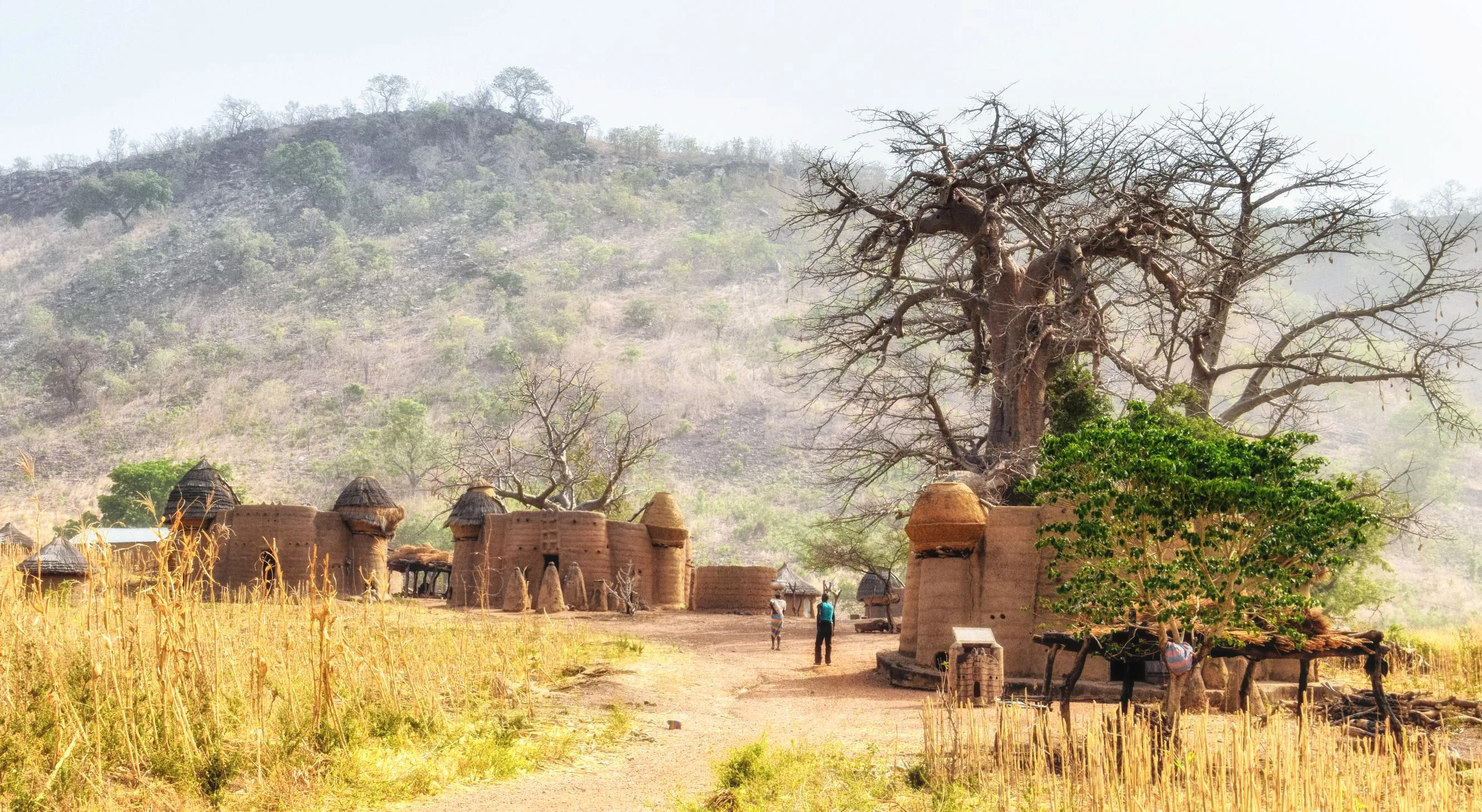
Up the narrowest country in West Africa, from a capital whose western edge is the Ghanaian border to mud tower-houses on the Benin one — the wax-cloth market the Nana Benz built and the burnt shell they are still waiting to move back into, a lagoon with an 1884 treaty signed on its shore, coffee hills and the one mountain, the concrete the Germans blew up in 1914, and Kabyé and Batammariba country in the north, stopping short of the Savanes region because it is under a state of emergency.
Lomé
Arrive, buy a SIM before leaving the airport, and draw cash — everything from here runs on notes and mobile money. Then walk west along the beach road until you reach the frontier, which is the point: Lomé is built hard against the Ghanaian border at Aflao and the city simply stops at it. Behind the shoreline is the port, the deepest water on this stretch of the West African coast and the reason a good deal of what Burkina Faso and Niger import arrives in Togo first.
Assigamé and Akodessewa
The Grand Marché — Assigamé to everyone who uses it — is the reason this city mattered to the region for fifty years. Its main building burnt down on the night of 11 January 2013 and the traders have been working from stalls around the site ever since; the replacement was years in being commissioned and is still not finished. Buy cloth here and you are buying at the end of a supply chain that used to run from a Dutch printing works through about fifty Togolese women and now runs mostly from Chinese mills through their successors. Later, east to Akodessewa, where the raw materials of Vodun practice are traded — skulls, dried animals, roots, and the practitioners who prescribe them. Agree the photography fee with the guides before you start rather than after.
Agbodrafo, Togoville and Aného
East along the coast, then inland to Lake Togo. At Agbodrafo the Woold Home is a low colonial house with a cellar in which people were held before being shipped; it is shown by local guides and it takes half an hour to see and considerably longer to stop thinking about. Cross the lagoon by pirogue to Togoville, where Mlapa III signed the treaty with Gustav Nachtigal on 5 July 1884 that made this coast a German protectorate — the church, the shrines and the Nachtigal monument are all within a few hundred metres of each other, which is roughly how the town understands itself. On to Aného, first capital of the colony, and Glidji beside it, where the Guin take the sacred stone each September and read the coming year from its colour.
North to Kpalimé
Back along the lagoon and up through Tsévié into the hills — about 170 kilometres and three and a half hours, and the last of it is the first real climbing in the country. Kpalimé sits at around 200 metres in coffee and cocoa country with the Ghanaian border on the ridge behind it. Give the afternoon to the market and the artisan centre, and to working out with a guide which walks are worth doing, because the answer depends entirely on how much rain has fallen.
Mount Agou
At 986 metres this is the highest ground in Togo, and the way to do it is on foot from Agou Nyogbo through the villages on the flank rather than by driving the service road to the mast on top. Three to four hours up through coffee plots and cocoa, with the Volta lowlands of Ghana opening out to the west as you climb. Start early: the haze thickens by ten and in the harmattan months there may be nothing to see by midday. There are installations at the summit itself, so take the local guide who knows where you may and may not walk.
Kloto and the waterfalls
The forest above Kpalimé at Kloto, which is what remains of the semi-deciduous cover on this side of the border and is the reason the area is known for butterflies. Château Viale on the ridge was built for a French colonial administrator and later used as a presidential residence; the walk up to it is the point rather than the building. The Womé falls run properly in the wet season and are a trickle outside it. The Kpimé falls are a different case: the water above them is held by a dam built in the early 1960s to generate for Kpalimé and Lomé, and the falls run when the operators let water down and not otherwise. Ask in town in the morning before spending the trip out there.
Notsé and Atakpamé
East out of the hills to Notsé, which the Ewe hold to be the town their ancestors left. The Agbogbo is an earth wall attributed to King Agokoli, and the founding account has the Ewe softening a section of it with water night after night until they could break through and scatter west and south — which is why the Agbogbo-za festival each September is a celebration of leaving rather than of arriving. Then north to Atakpamé on the N1, a hill town of steep streets and one of the wetter places in the country.
Kamina, then Sokodé
A few kilometres out of Atakpamé is a field with concrete blocks in it. Telefunken built the Kamina wireless station here between 1911 and 1914 to put Berlin in direct contact with its colonies, and by the spring of 1914 it was working over five thousand kilometres. British and French forces invaded Togoland within days of the war starting; the German commander had the station destroyed on the night of 24 August 1914 and surrendered days later, which made this the first German territory of the war to fall. The anchor blocks are what is left. Then 160 kilometres north on the N1 to Sokodé, the second city, Tem-speaking and mostly Muslim, and a different country from the coast in almost every respect.
Bassar
West into the iron country. The Bassar region smelted and forged for the whole of this part of the Volta basin for centuries — furnaces, slag heaps and the hoes and blades that were traded north and south long before anything European reached here — and archaeologists have been working the sites since the 1980s. Smelting stopped generations ago and the smithing did not; ask at the prefecture or through your driver for the villages where forges still run, because this is not a set-up visitor circuit and turning up unannounced achieves little. Back to Sokodé in the evening.
The Aledjo fault and Kabyé country
North on the N1 through Bafilo and the Faille d'Aledjo, where the road is cut through a rock wall in a gap barely wider than two lorries — the standard photograph of the Togolese highway and, more usefully, the point at which the landscape turns to bare granite hills. Kara by lunchtime. The afternoon goes to the Kabyé villages east and north of town, terraced and densely farmed, where smiths still work iron by hand at Landa. Twenty-odd kilometres north is Sarakawa, where the aircraft carrying Gnassingbé Eyadéma came down on 24 January 1974; he survived, the regime spent the next thirty years telling the story as a deliverance, and the crash site was built up into a monument accordingly. If you are here in July, the Evala wrestling that initiates young Kabyé men takes over the whole region for a week.
Koutammakou
North to Kandé on tarmac, then east on laterite towards the Benin border and the Batammariba country UNESCO inscribed in 2004. The takienta are two-storey houses built of mud, timber and rope — livestock below, living floor above, granaries and a sleeping terrace on the roof — and they were designed by people who expected to be raided. About fifty thousand hectares of it is inscribed and it is not a museum: these are lived-in compounds on working farmland. Visits are arranged through the villages, with a local guide and a village fee agreed at the start, and you ask before photographing anyone or anything. Nadoba's market day is the one to aim for. Back to Kara in the evening.
Down the N1
The whole country in one day, which is a thing you can do here and almost nowhere else on this coast: about 415 kilometres from Kara back to Lomé, seven to eight hours on the N1 once the coach's stops are counted, through savannah into the forest zone and out onto the lagoon plain. The long-distance coaches leave Kara early and are far better than the shared minibuses for this distance. Evening in Lomé, and the beach road for grilled fish.
Good to know
Visas are online only. Togo stopped issuing visas on arrival and stopped putting stickers in passports at embassies at the end of 2022; everything now goes through the government portal at voyage.gouv.tg, and you should apply at least five days before you fly because processing runs to about five working days. Fees are set in CFA francs — reckon on the order of 25,000 CFA, around €38, for a short single entry — and are paid by card or by Togolese mobile money. Citizens of the ECOWAS states enter without a visa under the bloc's free-movement protocol; everyone else needs the e-visa, and everyone, visa or not, has to file the online travel form before arrival. A yellow fever certificate is not conditional here: it is required of every arrival from nine months of age, it is genuinely checked at Lomé airport, and since 2016 the certificate is valid for life with no booster. Malaria is year-round and countrywide, Lomé included, so take prophylaxis for the whole twelve days rather than for the northern half. Medical facilities outside Lomé are thin and evacuation cover is worth having. The currency is the West African CFA franc, pegged to the euro at 655.957, which makes conversion arithmetic; ATMs work in Lomé, Kpalimé, Atakpamé, Sokodé and Kara and effectively nowhere else, cards are accepted only in the better Lomé hotels, and the country actually pays for things with T-Money and Flooz, so get a Togocom or Moov SIM with your passport on day one. The N1 is tarmac for the entire length of the country and generally good; the Kpalimé hill roads are patchy and the Kandé–Nadoba stretch is laterite that goes soft in the rains. Self-drive is legal with an International Driving Permit alongside your national licence — Togo drives on the right — but very few visitors do it, and a car with driver costs little more than the hire alone once you count the gendarmerie checkpoints, which are frequent and conducted entirely in French. Do not drive at night anywhere: unlit lorries, livestock and no hard shoulder make it the single largest risk on the trip. Zemidjan motorbike taxis do all short-distance work and are the most common cause of injury to visitors; agree the fare first and wear the helmet if one is offered. The south has two wet seasons, roughly April to July and a shorter one in September and October; the north has a single wet season from about May to October; December to February is the harmattan — dusty, hazy and the easiest driving of the year, though it is also when the waterfalls are least likely to be running. The far north is the part of this route that is missing on purpose. The Savanes region, which is everything above the Kara region, has been under a state of emergency since June 2022 following attacks by armed groups operating out of Burkina Faso; the emergency has been extended repeatedly, foreigners need government authorisation to travel there, and several foreign ministries advise against all travel within 30 kilometres of the Burkinabè border and against all but essential travel to the rest of the region. That puts Dapaong and the northern parks off the table. Koutammakou sits in the Kara region roughly forty kilometres south of that boundary and is normally open, but check your government's advice the week you travel rather than the month you book, and ask in Kandé before driving out to Nadoba. Politics is the other thing to watch, in Lomé rather than in the countryside: the constitutional change of May 2024 that moved Togo to a parliamentary system and made Faure Gnassingbé President of the Council of Ministers has produced recurring protests, and the demonstrations of June 2025 left at least seven people dead by civil-society counts, with internet access restricted during the worst of it. Avoid crowds and political gatherings entirely. French is the working language and there is very little English outside Lomé hotels; Ewe and Mina do the real work in the south, Tem and Kabyé in the north. Do not photograph the port, the airport, military installations or the presidential palace, and ask before photographing people anywhere — at Akodessewa and in Koutammakou there is a fixed fee for it and the local guides will tell you what it is.
Shorter or longer?
Add five or six days. Koutammakou continues across the border, so from Nadoba carry on to Boukoumbé and Natitingou, then south through Dassa to Abomey and the palaces of the Dahomey kings, and finish at Ouidah and Cotonou. Benin issues an e-visa online and the crossing at Nadoba is a small post — check it is open for foreigners before committing to it, and have the Cotonou–Hillacondji road as the fallback.
Lomé, Lake Togo and Aného, then Kpalimé for Mount Agou and the Kloto forest, and back. All of it on tarmac, none of it more than three hours from the capital, and it keeps the market, the lagoon towns and the only serious walking in the country. What it cuts is the north — the iron country, Kabyé country and Koutammakou — which is also most of the driving and most of the cost.