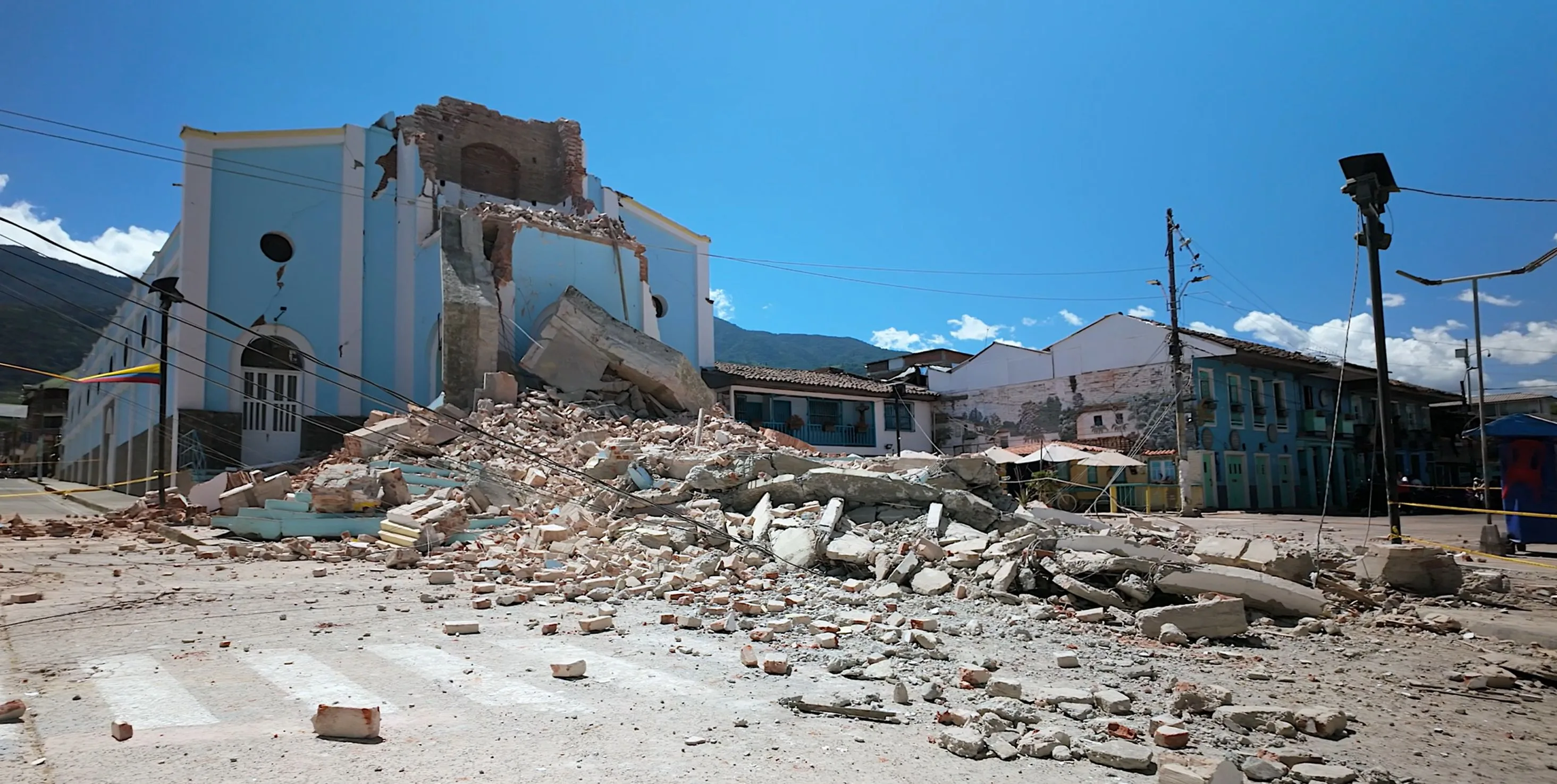
PlataRoncallo / stock.adobe.com
An Earthquake Without Borders
Colombia shook from a depth of more than a hundred kilometers. Venezuela still lives in the shadow of two shallow quakes. Geologically, no tectonic domino links them — yet in human terms they expose the same truth: magnitude alone does not make a disaster; the society it strikes does.
This text is a verified snapshot as of August 18, 2026. It will not be continuously updated - the tolls will keep changing. Every number in the text carries its institution and cutoff time.
Practical information for travelers - airport status and carrier policies - is in the service appendix at the end of the text.
On Monday, August 10, 2026, at 7:34:27 a.m. local time, stress that had accumulated inside a subducted tectonic plate released beneath western Colombia. The Colombian Geological Survey (SGC) put the moment magnitude at Mw 7.4, the epicentral area near San José del Palmar in the department of Chocó, and the depth at 103 kilometers. The revised solution from the U.S. Geological Survey (USGS) set the same magnitude, a depth of 110.3 kilometers, and a location roughly five kilometers from the town.
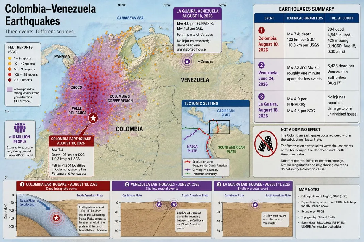
On a map, an epicenter looks like a single point. The actual disaster, however, did not unfold as a neat circle with the worst damage at its center. Strong shaking hit major cities and rural municipalities across Chocó, Valle del Cauca, and Colombia's coffee region. It was reported from more than 1,200 localities (SGC felt reports), it was felt in Panama and Venezuela, and, according to a USGS model, more than ten million people were exposed to strong to very strong ground motion.
Eight days after the Colombian earthquake, at 3:07 a.m. Venezuelan time, the coast near La Guaira shook again. FUNVISIS put the magnitude at 4.0 and the depth at ten kilometers; Colombia's SGC assessed the same event as a shallow Mw 4.8. The tremor was felt in parts of Caracas. For Venezuela - where, according to the latest official count, the two earthquakes of June 24 killed 6,438 people - this was not just another entry in a seismological catalog. It was the return of fear to a region still clearing rubble, assessing tens of thousands of homes, and housing displaced families.
The closeness in time between the Colombian quake and the Venezuelan sequence naturally created the impression of a regional domino effect. The available geological data do not support it. The Colombian earthquake originated deep inside the subducting Nazca plate. The Venezuelan quakes were tied to a shallow system at the boundary of the Caribbean and South American plates. A similar magnitude and neighboring countries do not add up to a common cause.
The State of the Data
The national Colombian balance used in this text has a cutoff of 6:30 a.m. Colombia time on August 18, 2026 (UNGRD). The forensic data on bodies received and identified have a cutoff of 1:00 p.m. on August 17 (Medicina Legal); the same institute's missing-persons register is updated to August 18. The most recent Venezuelan figures were released on August 17 by Jorge Rodríguez, president of the National Assembly, and relayed by the EFE news agency. All figures remain provisional and may change as victims are identified, the missing are located, and reports from individual municipalities are verified.
Event | Technical parameters | Toll at cutoff |
|---|---|---|
Colombia, August 10, 2026 | Mw 7.4; depth 103 km per SGC, 110.3 km per USGS | 304 dead, 4,548 injured, 426 missing (UNGRD, Aug 18, 6:30 a.m.) |
Venezuela, June 24, 2026 | Mw 7.2 and Mw 7.5 roughly one minute apart; shallow events | 6,438 dead per Venezuelan authorities (Aug 17) |
La Guaira, August 18, 2026 | Mw 4.0 per FUNVISIS; Mw 4.8 per SGC | No injuries reported; damage to one uninhabited house |
Technical data come from the SGC, the USGS, and FUNVISIS. The Colombian toll is UNGRD's national operational count; the Venezuelan toll is an official government figure relayed by EFE, not the result of an independent forensic audit.
How to Read Numbers After a Disaster: 1. No number without an institution, a date, and a cutoff time. The most recent number on social media is not necessarily the most accurate. 2. Different registers are not automatically a contradiction. An operational count, a forensic register, and regional reports have different methodologies, channels, and cutoffs.3. A number that goes down does not necessarily mean a cover-up. Corrections after removing duplicates and locating the missing tend to be a sign of a working system, not of manipulation. 4. A model is not a survey. Estimates of exposure, landslides, or economic losses are generated automatically from models; field verification comes later and may differ. 5. Official is not the same as independently verified. Government figures relayed by news agencies should be published with attribution, not as definitive fact.
1. Seven Thirty-Four: The Moment That Shook Half a Country
The Colombian quake struck at 7:34:27 a.m. local time - 12:34:27 UTC. The SGC placed its hypocenter at 4.99 degrees north and 76.29 degrees west, at a depth of 103 kilometers; its manually processed solution used 119 seismological stations. After its own recalculation, the USGS set the depth at 110.3 kilometers and the location about five kilometers from San José del Palmar.
The difference between 103 and 110.3 kilometers does not mean one institution must have made a mistake. Seismological networks use different stations, wave-velocity models, and location algorithms. First automatic solutions are routinely revised once more data arrive and manual review is done - the SGC itself initially communicated a preliminary magnitude of 6.7 and a depth of 82 kilometers, later revised. For a plain-language description of the event, what matters is that both revised solutions classify it as an intermediate-depth earthquake - an event roughly 70 to 300 kilometers below the surface.
The SGC called it the strongest earthquake by magnitude recorded in Colombia in the 21st century. The institute's director general, Julio Fierro Morales, ranked it the third strongest in the country's recorded history - surpassed only by the events of 1906 (Mw 8.8) and 1979 (Mw 8.1), both off the Pacific coast. That ranking, however, describes the size of the geological source, not automatically the number of victims or the extent of damage.
The best reminder is the 1999 earthquake near Armenia. Its magnitude was about 6.1 - far lower than the August event - but it was shallower and closer to cities. More than a thousand people died. A smaller earthquake directly beneath a vulnerable town can be deadlier than a far larger one buried deep underground.
2. A Hundred Kilometers Below the Surface
Western Colombia sits where the oceanic Nazca plate subducts eastward beneath the South American plate. The August earthquake, however, most likely did not occur on the shallow contact between the two plates.
The USGS assessed the mechanism as predominantly strike-slip faulting within the already subducted Nazca plate. The quake was thus likely related to deformation and bending of the descending slab at a depth of about 110 kilometers. It was not a shallow fault rupture just beneath San José del Palmar, nor a classic megathrust earthquake at the plate interface near the seafloor.
For earthquakes of this size, it is misleading to picture the source as a single point. The dot on the map is a simplified location of where the rupture began. The USGS notes that a strike-slip earthquake of this magnitude is typically associated with slip over an area roughly 105 kilometers long and 15 kilometers wide. The actual rupture area of the August event may differ from that typical size, but the principle matters: the energy was not released from a perfect point source.
Depth helps explain why the earthquake was felt over such a vast area. Before reaching the surface, the waves spread through a large volume of crust and upper mantle. Intermediate-depth earthquakes therefore often produce less extreme motion directly above the focus than equally large shallow events - but their effects can be spread across a much larger region.
That also explains the difference between the hypocenter and the epicenter. The hypocenter is the point of rupture at depth. The epicenter is the point on the surface directly above it. Neither figure by itself determines the street, city, or village where the worst damage will occur. That depends also on local ground conditions, the direction of wave propagation, the type of construction, population density, and building quality.
3. One Magnitude, Two Disasters
The strongest argument of this whole story comes from comparison. Within seven weeks, Colombia and Venezuela experienced earthquakes of similar magnitude - with outcomes an order of magnitude apart.
Factor | Colombia, August 10 | Venezuela, June 24 |
|---|---|---|
Depth | roughly 103–110 km | roughly 10 km |
Source | deformation inside the subducted Nazca plate | shallow fault environment at the Caribbean–South American plate boundary |
Shaking distribution | wide area, effects spread across a larger region | strong concentration of effects near the surface |
Exposure | major cities plus scattered mountain and rural communities | the dense northern urban corridor |
Toll at cutoff | 304 dead (UNGRD, Aug 18) | 6,438 dead per Venezuelan authorities (Aug 17) |
The 103-to-110-kilometer depth was both Colombia's protection and its problem. Protection, because the strongest energy had to pass through a thick layer of rock before reaching the cities. Problem, because a large source spread the shaking across a vast area home to millions. In Venezuela, the energy reached the surface over a very short path, and its strongest effects were concentrated in the country's most densely populated belt.
What happened next was decided by conditions at the surface. Soft river and valley sediments can amplify and prolong certain frequencies of seismic waves. Buildings respond differently depending on height, material, plan regularity, foundations, connection quality, and past alterations. Two neighborhoods a few kilometers apart can therefore suffer sharply different damage even at roughly the same distance from the epicenter.
The USGS noted in its model that the affected Colombian region contains resilient structures alongside buildings vulnerable to strong shaking - including homes with earthen walls, timber elements, and non-engineered construction. That assessment describes the regional building stock, not the cause of any individual collapse; that can only be established through technical inspection, documentation, and, where needed, material testing.
Colombia has seismic building codes and has built substantial civil-protection capacity over decades. But a code on paper does not automatically protect older houses, informal extensions, or buildings where the design was not followed. A building can be weakened by an added floor, a removed load-bearing wall, corroded reinforcement, or long-neglected maintenance. And a seismically resistant building need not come through a major earthquake undamaged: the core aim of many codes is to prevent sudden collapse and let people escape. A building can save lives and still be beyond economic repair.
The same magnitude also does not mean the same kind of motion. A short, sharp acceleration can damage a different set of buildings than longer swaying; high-rises and low masonry houses have different natural frequencies; local geological layers can amplify some frequencies and damp others.
A disaster, then, is not a synonym for a natural event. An earthquake is a geophysical event. A disaster arises where a geophysical event meets exposed people, vulnerable buildings, inaccessible services, and decisions accumulated over previous decades.
4. Magnitude Is Not Intensity
Moment magnitude Mw 7.4 is a single value describing the physical size of the earthquake's source. Intensity describes how the shaking manifested at a specific place - whether people felt it, how furniture and buildings behaved, and what damage occurred.
The SGC received 20,677 "Sismo Sentido" (felt-report) forms, through which residents reported the tremor and its effects. The highest reported intensity reached grade 7 on the European Macroseismic Scale (EMS-98) - a grade the scale labels *damaging*. These were not 20,677 confirmed damage claims but citizen reports used to build the macroseismic map.
The USGS's automated PAGER model estimated roughly 5.5 million people in the MMI VI zone (strong shaking), 5.16 million at MMI VII (very strong), and 1.2 million at MMI VIII (severe). Among cities in the modeled MMI VIII zone it listed Pereira, Dosquebradas, Quibdó, Cartago, Buenaventura, and Armenia; Cali fell in the MMI VII zone.
These figures are not the result of visiting every house. PAGER combines a shaking model, population estimates, and general building-stock data. The USGS itself cautions that the product is generated automatically, carries input uncertainties, and primarily assesses potential losses from structural damage. It is useful for early decision-making, not a substitute for a field survey.
Nor does the question of how long the earthquake lasted have a single universal answer. The nearest SGC monitoring stations recorded motion for roughly 90 seconds to two minutes. A person on an upper floor, on soft sediment, or in a distant city may have perceived a different duration and character of motion. And the length of the full instrumental record is not the same as the duration of the strongest shaking.
Despite the large magnitude, no tsunami threat arose. Colombia's maritime authority DIMAR announced shortly after the event that the earthquake lacked the parameters needed to generate a tsunami on the Pacific coast. Its source lay deep beneath land, not in a significant vertical displacement of the seafloor.
5. 304 Dead - and Numbers That Keep Moving
As of 6:30 a.m. on August 18, Colombia's National Unit for Disaster Risk Management (UNGRD) recorded 304 dead, 4,548 injured, 426 missing, and 356 rescued. Fifteen departments and 472 municipalities were affected. Authorities counted 123,789 affected families - 292,043 people in total.
"Affected" does not automatically mean injured or homeless. Operational registers use the category for households hit by loss of housing, property damage, service interruptions, evacuation, or another immediate consequence of the disaster. The figure therefore describes the breadth of social impact, not one specific form of harm.
Colombia's National Institute of Legal Medicine and Forensic Sciences (Medicina Legal) said in its August 17 (1:00 p.m.) report that it had received 304 bodies from the departments of Chocó, Caldas, Risaralda, and Valle del Cauca. Three hundred victims had been identified, including 22 minors, and 293 bodies had already been returned to families.
The same institute's missing-persons register was shifting literally day by day: 423 missing as of 1:00 p.m. on August 16, 348 on August 17, and 290 in the August 18 report. In two days, more than 130 cases left the forensic register. A change like that can mean that some of those sought were located alive, some reports were matched against already identified victims, and some duplicates were removed - not that the earlier register was invented.
The gap between 290 missing in the forensic register and 426 in UNGRD's national operational count is likewise not necessarily evidence of error. The institutions run different registers, receive reports through different channels, and work to different cutoffs. A person may be reported to local police, rescuers, or the municipality before their case reaches the forensic register; conversely, someone found is not removed from every system at the same moment. Medicina Legal's own director, Ariel Cortés, publicly called for unifying the missing-persons counts, because reports can overlap with bodies already returned to families.
In a disaster, it is therefore misleading to publish a number on its own, without three more pieces of information: who issued it, what time it is valid for, and what exactly the category means. A number that drops after duplicate checks does not mean victims are being hidden - and the toll in this text will almost certainly look different a week from now.
6. Homes, Hospitals, Bridges
The national inventory with an August 18 cutoff listed 134,342 damaged and 29,554 destroyed homes, and 267 collapsed buildings. These are rolling operational categories that can change after repeated technical inspection.
Also affected were 303 health facilities, 3,443 educational buildings, and 3,905 community centers. Such figures cannot be read merely as a list of future repairs. A damaged hospital limits care for the injured; a damaged school interrupts education and often also removes a space that could serve as emergency shelter; a non-functioning community center weakens local aid distribution.
Transport and utility damage included 413 roads, five airports, 86 water systems, 49 road bridges, and 13 pedestrian bridges. Authorities also recorded 1,323 affected and 496 rescued animals.
In the mountainous, rural geography of western Colombia, damage to a single road can mean more than its repair cost. It can cut a village off from a hospital, keep a structural engineer from arriving, slow deliveries of water and food, and make debris removal impossible. Likewise, the loss of a farm animal is not a marginal line item: for a family it can mean losing food, savings, and future income at once.
Nor does the inventory of damaged homes say how many are safe to occupy right now. A house can show visible cracks yet have a sound load-bearing structure. Another can look intact while its columns, connections, or foundations are compromised. A rapid habitability check is only a first filter; it does not replace a detailed structural assessment.
7. Chocó: The Disaster That Is Harder to See
The most dramatic images come from cities. A collapsed urban building creates a clearly bounded scene where you can bring a crane, rescue dogs, doctors, and TV crews. A rural disaster tends to be scattered.
In Chocó and other mountainous areas, communities lie far from main roads, mobile coverage is uneven, and access can depend on a single bridge or slope. The International Federation of Red Cross and Red Crescent Societies (IFRC) warned that landslides, damaged roads, airport closures, and communication outages were complicating access, above all to remote parts of Chocó.
On August 13, OCHA explicitly cautioned that the toll could grow because of limited access and possible underestimation. The needs of rural communities, where state and humanitarian presence remained thin, were flagged as especially critical.
That is why the national counts of affected people, municipalities, and damaged homes moved so sharply during the first week. It was not only new damage accumulating. Municipalities were progressively entering the inventory as authorities finally received usable reports from them - or were finally able to verify them.
Recovery in such places cannot be a scaled-down version of rebuilding Cali or Pereira. A family needs more than a new house. It needs a safe water source, an access road, a school, a way to get produce to market, and restored local income. A new roof without fixing an unstable slope or a severed road may only push the problem into the next rainy season.
8. Aftershocks: Hundreds of Events, No Precise Calendar
By noon on the day of the mainshock, the SGC had recorded the first 18 aftershocks, with magnitudes from 1.4 to 4.8. By 1:30 p.m. on August 17, the SGC counted 332 subsequent earthquakes: 21 above magnitude 3 and two above magnitude 4. The full recorded range ran from 0.6 to 4.8.
Aftershock counts depend on methodology. A network able to detect very small events will count more of them than a global catalog tracking only stronger quakes. The number also changes with manual review, merging of duplicate records, and widening of the time or geographic window under study.
Aftershocks generally weaken and become less frequent over time. But there is no hour after which one can declare that no further felt tremor will come. The SGC warns that the sequence can continue for days, weeks, or months.
For residents, the biggest problem is not only the magnitude of the aftershocks. Even a smaller tremor can bring down a loosened building element or finish the collapse of a structure the mainshock weakened. A house's safety therefore cannot be judged simply by the fact that it was still standing after the first shock.
The earthquake also raised the risk of landslides and of failures in water-saturated ground. Automated USGS models rated the potential for landslides and liquefaction as significant - but such maps are forecasts built from shaking, topography, and estimated soil properties, not a field inventory of confirmed events.
9. The First Hours: Rescue on Incomplete Information
After the earthquake, the Colombian government activated the national crisis room and the National Disaster Risk Management Committee. On day one, four urban search-and-rescue (USAR) teams were deployed from Bogotá, Envigado, Yopal, and Medellín (PAHO situation report no. 2); Bogotá offered heavy machinery and Antioquia air assets.
The same day, the government declared a national disaster situation. That legal regime allowed faster mobilization of budgetary and administrative mechanisms, coordination of territorial authorities, and preparation for the shift from immediate rescue to recovery.
The priority was not only pulling people from the rubble. Among the first urgent needs, OCHA listed temporary shelter, health care, food, water, hygiene, protection, restored education, and communications. Power and telecom outages, meanwhile, made it harder to establish who needed help in the first place.
In Cali, the character of the operation gradually changed. The city's official report with a cutoff of 5:00 p.m. on August 17 listed 25,032 tons of rubble removed; the next report, on August 18, already put it above 28,000 tons. Firefighters continued working at sites where victims might still be found, but much of the effort was shifting from searching for the living to recovering the dead, stabilizing buildings, and beginning recovery.
The rubble figure alone says nothing about how many buildings were made safely accessible. Rapid debris removal can be necessary for transport and sanitation, but at sites where victims may lie, it must proceed under the control of search and forensic teams. Speed and thoroughness are not opposites in this work; they have to be coordinated.
10. When Numbers Became Part of Crisis Management
In the first days, sharp gaps opened between national and regional tolls. On August 11, President Abelardo de la Espriella cited 181 dead, while the sum of figures from the hardest-hit regions, according to EFE, came to at least 240. The gap emerged just as UNGRD announced that, on presidential instruction, all official information about the emergency would be issued exclusively by the presidential office.
Centralizing data has a legitimate purpose. It can remove duplicates, unify categories, and prevent one victim from being counted by local police, a hospital, and the fire service alike. But it can also create a delay between what regional authorities already know and what is cleared for release in the national count.
The discrepancy alone therefore does not prove manipulation. It is, however, grounds to demand that the state publish, with every update, the cutoff time, the source institutions, the category definitions, and information on corrections to the previous count.
For the family of a missing person, the difference between registers is not an academic question. It determines whether the case is being actively pursued, whether the data reached hospitals and morgues, and whether photographs, biological samples, and identity documents were correctly matched. Trustworthy data are not an accessory to a rescue operation. They are part of it.
11. The Dispute Over Foreign Rescue Teams
One of the most sensitive moments of the response was how foreign search teams were received. In the first days, the Colombian government prioritized material and logistical aid and said domestic rescue capacity was sufficient. The approach later changed, and international teams began entering zhe country.
On August 13, Mexican President Claudia Sheinbaum said Colombia had not approved the deployment of a Mexican military rescue brigade, citing a demand for additional certification. Mexico continued sending material aid regardless - more than 56 tons, according to Colombia's public broadcaster RTVC. Separately, the volunteer group Topos Aztecas reached Cali by agreement with local authorities and worked at collapse sites.
Colombia's UNGRD subsequently confirmed the presence of specialized teams from three countries and stressed that the accepted groups were recognized within the international INSARAG system. At the same time, it urged mayors and governors not to let uncertified groups enter rescue operations on their own.
Certification is not pointless bureaucracy. A team working on an unstable structure must be self-sufficient, coordinated, and able to operate safely, and must not drain local rescuers of accommodation, fuel, or protective equipment. On the other hand, during the time-critical phase, the state must explain clearly and quickly what credential it requires, who recognizes it, and why one group received clearance and another did not.
The accurate conclusion, then, is not that Colombia refused all foreign help. This was a dispute over the timing, authorization, certification, and coordination of foreign teams. The open question for the after-action review is whether the criteria were applied quickly, transparently, and consistently enough.
12. Aid: The Gap Between Pledge and Delivery
UN Emergency Relief Coordinator Tom Fletcher allocated five million U.S. dollars for Colombia from the Central Emergency Response Fund (announced by the UN spokesperson on August 13). OCHA said the funds were to go primarily to life-saving interventions in hard-to-reach rural areas with limited institutional presence.
On August 12, the European Commission allocated €2.1 million for health care, water, hygiene, shelter, food, protection, and cash support, and activated Copernicus satellite mapping. The German Red Cross immediately redirected €100,000 from an EU-funded project to the needs of 2,500 families in Chocó and Valle del Cauca. Through the EU Civil Protection Mechanism, Sweden offered 150 tents and 360 blankets, Germany 3,000 kitchen sets and 2,500 water filters, and Luxembourg 79 tents (Commission announcement of August 17).
Norway allocated ten million Norwegian kroner through the Red Cross movement (foreign ministry press release of August 14). The contribution was to support acute health care, clean water, disease prevention, temporary shelter, essential household items, restored communications, and reunification of families separated in the disaster.
In judging aid, four different things must be kept apart: money pledged, money contractually allocated, material physically delivered to the country, and aid actually handed to a specific community. One press release can announce an offer of tents, another their departure, a third their distribution. All three can be true - and they do not describe the same phase.
The hardest part of aid often happens beyond the airport and the central warehouse. A water filter does not help a community whose bridge is destroyed. A tent does not help without a safe site, sanitation, and protection. Money in a central fund saves no lives until it has been converted into personnel, transport, medicine, or a functioning service.
13. Two Shallow Earthquakes One Minute Apart
On June 24 at 6:04 p.m. local time, FUNVISIS recorded an Mw 7.2 earthquake roughly 25 kilometers east of San Felipe. A minute later, it registered a second earthquake, Mw 7.5, roughly 18 kilometers northwest of San Felipe.
On the location of the second source, the catalogs disagree substantially - this is no minor offset. In its August situation report, OCHA cited an updated USGS solution with an epicenter roughly 17 kilometers west of Catia La Mar, on the coast of La Guaira state - a locality some two hundred kilometers from San Felipe as the crow flies. A difference like that can stem from different stations and location models; it does not automatically mean there was another, separate mainshock. Until one of the institutions publishes a revised joint solution, the correct approach is to cite both locations with attribution.
Both events were shallow, with foci roughly ten kilometers below the surface. They occurred in a tectonically active belt shaped by the interaction of the Caribbean and South American plates. In this context, FUNVISIS points to Venezuela's main fault systems - Boconó, San Sebastián, and El Pilar - along with other active structures.
Unlike the Colombian earthquake, the Venezuelan energy reached the surface over a very short path, and the strongest effects concentrated in the northern urbanized corridor. That does not mean depth explains everything. The scale of the disaster was also shaped by population density, building condition, local sediments, the availability of open space, hospital capacity, and the time needed to reach collapsed structures.
14. Venezuela's Toll: Official, but Not Independently Audited
According to figures released on August 17 by Jorge Rodríguez, president of Venezuela's parliament, the death toll rose to 6,438 - an increase of 137 over the previous weekly update.
Rodríguez also cited 86,358 people treated in hospitals. That figure cannot automatically be labeled a count of the injured. People hospitalized or treated as outpatients may include repeat visits, psychological distress, complications of chronic illness, or the consequences of living in temporary shelter.
According to the same update, Venezuelan authorities had assessed 59,109 dwellings. Of these, 34,680 were classified as habitable, 13,733 as habitable with restrictions, and 10,696 as high-risk. The government said it had handed over 335 replacement dwellings to affected families.
OCHA, with a cutoff of August 3, was still citing 6,125 dead, 16,740 injured, and 60,992 people who had received hospital care. As of July 26, national authorities reported 107 temporary camps still operating, housing 24,477 people. The humanitarian response was targeting the needs of 1.3 million people, and roughly 212,000 of those affected had already gained access to aid or basic services.
These older and newer figures should not be mechanically combined into one total - they have different cutoffs and categories. But they show that, nearly two months on, the Venezuelan disaster was not a closed rescue event. It was simultaneously a crisis of housing, health, income, sanitation, and long-term displacement.
All current Venezuelan figures must be published with clear attribution. They are figures from the government and national bodies, relayed by international agencies. Without a full public forensic register, they cannot be presented as an independently verified final count.
15. La Guaira, August 18
On August 18 at 3:07 a.m. Venezuelan time, FUNVISIS recorded an Mw 4.0 earthquake roughly ten kilometers northwest of La Guaira, at a depth of ten kilometers. The tremor was felt in parts of Caracas.
Colombia's SGC assessed the same event as Mw 4.8, shallower than 30 kilometers and 24 kilometers from La Guaira. Its catalog lists the time as 2:07:17 Colombian local time - the same 7:07 UTC. The one-hour gap between the local times is not a contradiction about when the event occurred; it is the consequence of Colombia and Venezuela sitting in different time zones.
The difference between Mw 4.0 and Mw 4.8 is more than simple rounding. It can stem from different networks, models, magnitude types, and source locations. A careful text should not pick the higher value because it sounds more dramatic; it should cite both and attribute each to its agency.
Immediately after the event, the Venezuelan government said it had no damage reports. Later, however, local emergency services responded to an uninhabited house in the Los Hermanos de Carapita neighborhood, where the roof and other parts of the structure were damaged; no injuries were reported (El Nacional). The two reports do not contradict each other - a first nationwide statement can be issued before a local incident reaches the central system. The precise formulation is therefore: no widespread damage was reported immediately; localized damage to one uninhabited house, with no injuries, was confirmed later.
Feliciano De Santis, president of the Venezuelan Society of Geologists, described the tremor as part of the tail of the June sequence and warned that similar aftershocks could continue for another three to four months. That is an expert assessment of an aftershock sequence, not a prediction of the date or magnitude of the next quake. Nor was the La Guaira tremor the last seismic event of the day - FUNVISIS later recorded, among others, an Mw 3.3 near La Victoria. But La Guaira was the most widely felt event in the region struck by the June disaster.
16. Did Venezuela Trigger the Colombian Earthquake?
The available evidence says no.
The Colombian earthquake originated roughly 110 kilometers below the surface, most likely inside the subducting Nazca plate. Venezuela's June sequence was shallow and tied to an entirely different tectonic environment at the contact of the Caribbean and South American plates. The source structures, depths, and mechanisms of motion all differ.
In an NPR report on August 12, USGS scientist William Barnhart called the closeness in time and geography a coincidence. He noted that an earthquake of roughly magnitude seven occurs somewhere on Earth about once a month on average. Two large events in neighboring countries can therefore look like one regional sequence even though they arose independently.
Large earthquakes can, under certain conditions, alter stress on nearby faults or trigger distant, weaker tremors. But the fact that one event followed another is not enough to claim causation. Scientists would need a corresponding physical mechanism, a spatial pattern, and seismological data. For Colombia and Venezuela, no such evidence has been identified.
Similarly, the SGC explicitly rejected any link between the Colombian earthquake and activity at the Puracé volcano. The quake had a tectonic source in a different setting and was not the cause of the volcano's alert status at the time.
17. Reconstruction: Going Back Is Not Enough
Clearing rubble is the visible part of recovery. The hardest decisions come afterward: which houses to repair, which to strengthen, which to demolish - and which never to rebuild on the original site.
Colombia has an extensive legal and institutional framework for disaster risk management. The earthquake, however, was another reminder that a modern state does not function as a collection of independent buildings. A hospital needs a road, electricity, water, telecommunications, and staff. The failure of a single system can knock out a facility that structurally survived the earthquake itself.
Real recovery will therefore need at least four things.
A trustworthy damage register. One database must link the address, the household, ownership or tenure, technical condition, aid provided, and the next decision. Without it, some households risk drawing support from multiple programs while others - informal and rural ones above all - receive nothing.
Technical decisions instead of political deadlines. Handing over new houses quickly can look like success, but building on an unstable slope, without water, or without quality control only manufactures the next disaster.
Restoring incomes and services. A family may have lost a house, a shop, tools, documents, transport links, and a school place all at once. Building materials alone do not restore a life.
Transparent public spending. Emergency procurement is often necessary, but it raises the risk of inflated contracts, conflicts of interest, and weak oversight. Publicly accessible data on contractors, prices, locations, deadlines, and inspection results should be part of recovery from day one.
18. What We Know - and What We Still Don't
We know when the Colombian mainshock began, its revised magnitude, and its approximate depth. We understand its mechanism well enough to separate it from the Venezuelan sequence. We have a national count of the dead, the injured, the missing, and damaged buildings, each with a specific cutoff. We still do not know the final toll. Not all damaged buildings have had a detailed inspection. Not all rural communities have equal access to damage registration. Nor do we know the final cost of reconstruction, or the precise share of failures caused by poor construction, unsuitable ground, neglected maintenance, or a combination of all three.
No scientific method can reliably announce the exact day, hour, place, and magnitude of the next earthquake. Seismologists can map hazards, monitor activity, and produce statistical aftershock forecasts - not a calendar of future quakes. And prediction should not be confused with early warning: a warning system detects an earthquake that has already begun and can give more distant places a few seconds before the stronger waves arrive. It cannot announce an event hours or days ahead.
After the disaster, claims also spread that the earthquakes were caused by humans, foreign states, or the HAARP facility. That explanation has no support in the seismological data or in the known physical capabilities of that technology (verification: Factchequeado). The recorded mechanisms match natural processes at active tectonic boundaries and inside a subducted plate.
19. Two Tectonic Events, One Shared Lesson
The Colombian earthquake did not originate in Venezuela. The Venezuelan quakes did not trigger the deep rupture in the Nazca plate. Geologically, these are distinct events in distinct tectonic systems.
What they share is not a physical cause but a society's vulnerability.
In Colombia, great depth softened the most extreme surface effects - but it did not protect cities with vulnerable buildings, or villages that the loss of a single road can cut off from help. In Venezuela, shallow quakes struck the dense northern corridor and produced a disaster with an official toll in the thousands and tens of thousands of homes awaiting assessment.
Magnitude tells you how much energy was released in the ground. It does not tell you whether the hospital stays open, whether the bridge holds, whether a family lives in an inspected building, or whether rescuers get the right address in time.
The final outcome of the Colombian earthquake will therefore not be measurable only in victims counted or tons of rubble hauled away. It will show in how many children return to safe schools, how many hospitals still function after the next tremor, how many rural communities make it into the aid register, and how many new houses stand on ground that was actually assessed.
The most important question after a disaster is not whether the country can return to how things were before August 10.
It is whether it will choose not to rebuild the very same vulnerability.
20. Traveling in Earthquake-Hit Colombia
This appendix goes stale faster than the rest of the text: operational and carrier information is valid as of August 11–14, 2026. Before traveling, verify the current status directly with the carrier, the airport, and local authorities.
The most recent nationwide operational bulletin of Colombia's civil aviation authority (Aerocivil) located for this article was issued on August 11. According to it, Cali and Quibdó had resumed normal commercial operations. Armenia had resumed controlled flights but was temporarily not to serve as an alternate airport. Buenaventura and Manizales were open as uncontrolled airfields; in Manizales the control tower was damaged, though the runway and movement areas were declared safe.
In the same bulletin, regular commercial operations at Pereira's Matecaña airport remained suspended, with state, medical, search-and-rescue, and humanitarian flights permitted. Because operational decisions can change after each new inspection, the August 11 bulletin cannot be treated as a guarantee of the status of any specific flight on a later date.
In its August 13 update (2:13 p.m. Colombia time), Avianca extended flexible conditions to flights to or from Pereira, Armenia, Cali, and Quibdó with original travel dates through August 30. Passengers could change dates free of charge through September 30, 2026, reroute via other Colombian airports subject to availability, or request refunds of unused segments under the carrier's terms. Operations at Pereira remained suspended, per the same notice, pending safety inspections of airport infrastructure.
LATAM Airlines Colombia extended its measures to flights to or from Pereira, Cali, and Armenia with travel dates from August 10 to 23: free flight changes, rerouting subject to availability in the same cabin, or refunds, with rebooking possible for up to a year from the original date.
A functioning airport, however, does not mean a trouble-free journey. Local ground transport can be affected by damaged roads and bridges, landslides, controlled access points, and the priority given to humanitarian convoys. Travelers should rely not on an old map or a single news article but on current confirmation from the carrier, the airport, and local authorities.
A tourist trip into an area of active search operations or emergency shelter can, moreover, absorb capacity residents need: rooms, transport, water, fuel, and medical care. The question is therefore not only "can I get there" but "is a visitor's presence responsible right now."
Sources
- SGC - event SGC2026pqqmro
catalog entry for the August 10, 2026 event (SGC2026pqqmro); "Sismo Sentido" felt reports (20,677 forms); statements on the historical ranking and on the Puracé volcano; catalog entry for the August 18, 2026 La Guaira event
- USGS
revised solution for event us6000tjl2, PAGER and ShakeMap models (August 10–17, 2026); comments by William Barnhart (NPR, August 12, 2026)
- FUNVISIS
solutions for the events of June 24 and August 18, 2026
- Alcaldía de Cali, PMU
- SGC / USGS
historical catalogs (the 1906, 1979, and 1999 Armenia earthquakes)
- UNGRD
national balance, cutoff August 18, 2026, 6:30 a.m. (also published via RTVC Noticias); confirmation of international USAR teams
- Instituto Nacional de Medicina Legal y Ciencias Forenses
official reports of August 16 (1:00 p.m.), August 17 (1:00 p.m.), and August 18, 2026
- Alcaldía de Santiago de Cali
Unified Command Post (PMU) reports, August 12–18, 2026 (rubble, RUFE assessments, personnel)
- OCHA / UN
situation reports: Colombia (August 13, 2026), Venezuela (cutoffs July 26 and August 3, 2026); CERF allocation announcement (UN spokesperson's briefing, August 13, 2026)
- IFRC
operational reports on Colombia
- PAHO
situation report no. 2 (deployment of USAR teams from Bogotá, Envigado, Yopal, and Medellín)
- EFE
Venezuelan toll of August 17, 2026 (Jorge Rodríguez); national-vs-regional count discrepancies of August 11, 2026